You are here: Home > Network List > AK - Alaska Regional Network Stations List
> Station GLI Glacier Island > Earthquake Result Viewer
GLI Glacier Island - Earthquake Result Viewer
| Earthquake location: |
Tanimbar Islands Reg., Indonesia |
| Earthquake latitude/longitude: |
-7.1/130.0 |
| Earthquake time(UTC): |
2023/01/09 (009) 17:47:34 GMT |
| Earthquake Depth: |
95 km |
| Earthquake Magnitude: |
7.6 mww |
| Earthquake Catalog/Contributor: |
NEIC PDE/us |
|
| Network: |
AK Alaska Regional Network |
| Station: |
GLI Glacier Island |
| Lat/Lon: |
60.88 N/147.09 W |
| Elevation: |
430 m |
|
| Distance: |
92.7 deg |
| Az: |
29.07 deg |
| Baz: |
260.351 deg |
| Ray Param: |
0.04137014 |
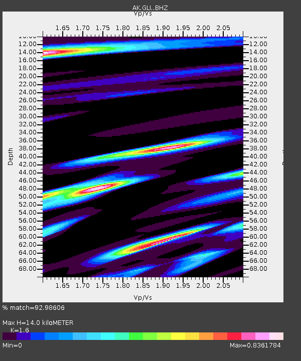
| Estimated Moho Depth: |
14.0 km |
| Estimated Crust Vp/Vs: |
1.60 |
| Assumed Crust Vp: |
6.566 km/s |
| Estimated Crust Vs: |
4.104 km/s |
| Estimated Crust Poisson's Ratio: |
0.18 |
|
| Radial Match: |
92.98606 % |
| Radial Bump: |
400 |
| Transverse Match: |
83.287926 % |
| Transverse Bump: |
400 |
| SOD ConfigId: |
29823551 |
| Insert Time: |
2023-01-23 17:49:43.750 +0000 |
| GWidth: |
2.5 |
| Max Bumps: |
400 |
| Tol: |
0.001 |
|

Signal To Noise
| Channel | StoN | STA | LTA |
| AK:GLI: :BHZ:20230109T18:00:04.248021Z | 4.2123623 | 1.5439023E-6 | 3.6651696E-7 |
| AK:GLI: :BHN:20230109T18:00:04.248021Z | 1.3772299 | 5.1110436E-7 | 3.711104E-7 |
| AK:GLI: :BHE:20230109T18:00:04.248021Z | 1.4811571 | 6.0668236E-7 | 4.096003E-7 |
| Arrivals |
| Ps | 1.3 SECOND |
| PpPs | 5.4 SECOND |
| PsPs/PpSs | 6.7 SECOND |


