You are here: Home > Network List > AK - Alaska Regional Network Stations List
> Station NIKH Nikolski High Hill > Earthquake Result Viewer
NIKH Nikolski High Hill - Earthquake Result Viewer
| Earthquake location: |
Tanimbar Islands Reg., Indonesia |
| Earthquake latitude/longitude: |
-7.1/130.0 |
| Earthquake time(UTC): |
2023/01/09 (009) 17:47:34 GMT |
| Earthquake Depth: |
95 km |
| Earthquake Magnitude: |
7.6 mww |
| Earthquake Catalog/Contributor: |
NEIC PDE/us |
|
| Network: |
AK Alaska Regional Network |
| Station: |
NIKH Nikolski High Hill |
| Lat/Lon: |
52.97 N/168.85 W |
| Elevation: |
199 m |
|
| Distance: |
78.9 deg |
| Az: |
32.655 deg |
| Baz: |
242.311 deg |
| Ray Param: |
0.049118232 |
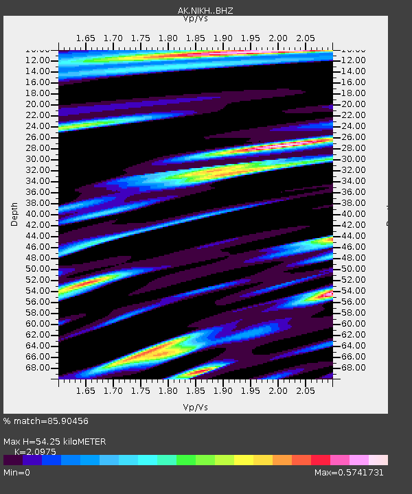
| Estimated Moho Depth: |
54.25 km |
| Estimated Crust Vp/Vs: |
2.10 |
| Assumed Crust Vp: |
5.88 km/s |
| Estimated Crust Vs: |
2.804 km/s |
| Estimated Crust Poisson's Ratio: |
0.35 |
|
| Radial Match: |
85.90456 % |
| Radial Bump: |
400 |
| Transverse Match: |
73.21189 % |
| Transverse Bump: |
400 |
| SOD ConfigId: |
29823551 |
| Insert Time: |
2023-01-23 17:51:11.880 +0000 |
| GWidth: |
2.5 |
| Max Bumps: |
400 |
| Tol: |
0.001 |
|

Signal To Noise
| Channel | StoN | STA | LTA |
| AK:NIKH: :BHZ:20230109T17:58:56.228002Z | 2.52744 | 7.96041E-6 | 3.1495938E-6 |
| AK:NIKH: :BHN:20230109T17:58:56.228002Z | 2.3763833 | 3.2406954E-6 | 1.363709E-6 |
| AK:NIKH: :BHE:20230109T17:58:56.228002Z | 0.56743485 | 1.4884263E-6 | 2.6230787E-6 |
| Arrivals |
| Ps | 10 SECOND |
| PpPs | 28 SECOND |
| PsPs/PpSs | 38 SECOND |


