You are here: Home > Network List > AK - Alaska Regional Network Stations List
> Station PS12 TAPS Pump Station 12, AK, USA > Earthquake Result Viewer
PS12 TAPS Pump Station 12, AK, USA - Earthquake Result Viewer
| Earthquake location: |
Tanimbar Islands Reg., Indonesia |
| Earthquake latitude/longitude: |
-7.1/130.0 |
| Earthquake time(UTC): |
2023/01/09 (009) 17:47:34 GMT |
| Earthquake Depth: |
95 km |
| Earthquake Magnitude: |
7.6 mww |
| Earthquake Catalog/Contributor: |
NEIC PDE/us |
|
| Network: |
AK Alaska Regional Network |
| Station: |
PS12 TAPS Pump Station 12, AK, USA |
| Lat/Lon: |
61.47 N/145.15 W |
| Elevation: |
563 m |
|
| Distance: |
93.7 deg |
| Az: |
28.624 deg |
| Baz: |
262.08 deg |
| Ray Param: |
0.041157108 |
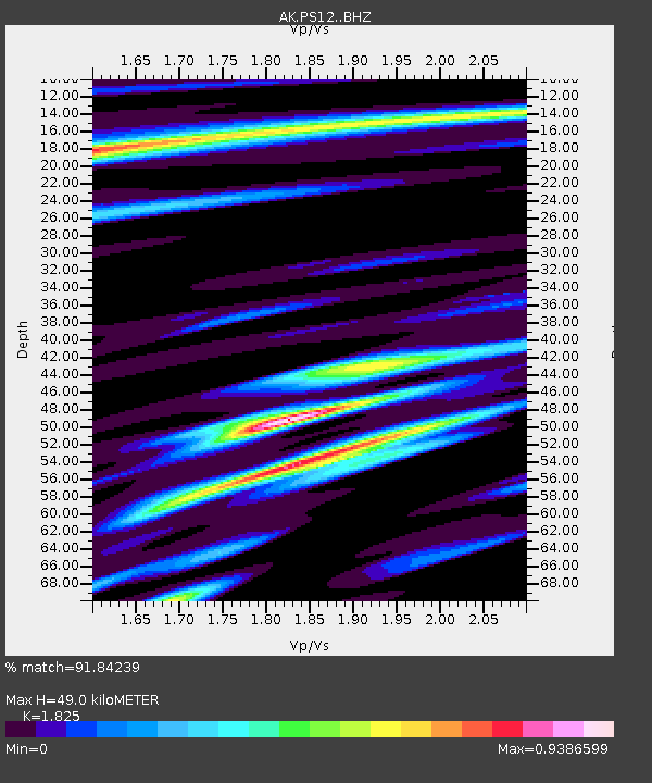
| Estimated Moho Depth: |
49.0 km |
| Estimated Crust Vp/Vs: |
1.83 |
| Assumed Crust Vp: |
6.566 km/s |
| Estimated Crust Vs: |
3.598 km/s |
| Estimated Crust Poisson's Ratio: |
0.29 |
|
| Radial Match: |
91.84239 % |
| Radial Bump: |
400 |
| Transverse Match: |
77.64583 % |
| Transverse Bump: |
400 |
| SOD ConfigId: |
29823551 |
| Insert Time: |
2023-01-23 17:51:41.995 +0000 |
| GWidth: |
2.5 |
| Max Bumps: |
400 |
| Tol: |
0.001 |
|

Signal To Noise
| Channel | StoN | STA | LTA |
| AK:PS12: :BHZ:20230109T18:00:08.947973Z | 3.3672836 | 1.0435199E-6 | 3.098996E-7 |
| AK:PS12: :BHN:20230109T18:00:08.947973Z | 1.0788089 | 3.8586404E-7 | 3.57676E-7 |
| AK:PS12: :BHE:20230109T18:00:08.947973Z | 2.2756283 | 4.525949E-7 | 1.9888788E-7 |
| Arrivals |
| Ps | 6.3 SECOND |
| PpPs | 21 SECOND |
| PsPs/PpSs | 27 SECOND |


