You are here: Home > Network List > AT - Alaska Tsunami Warning Seismic System Stations List
> Station SDPT Sand Point, Alaska > Earthquake Result Viewer
SDPT Sand Point, Alaska - Earthquake Result Viewer
| Earthquake location: |
Tanimbar Islands Reg., Indonesia |
| Earthquake latitude/longitude: |
-7.1/130.0 |
| Earthquake time(UTC): |
2023/01/09 (009) 17:47:34 GMT |
| Earthquake Depth: |
95 km |
| Earthquake Magnitude: |
7.6 mww |
| Earthquake Catalog/Contributor: |
NEIC PDE/us |
|
| Network: |
AT Alaska Tsunami Warning Seismic System |
| Station: |
SDPT Sand Point, Alaska |
| Lat/Lon: |
55.35 N/160.48 W |
| Elevation: |
74 m |
|
| Distance: |
84.4 deg |
| Az: |
32.515 deg |
| Baz: |
249.071 deg |
| Ray Param: |
0.045333 |
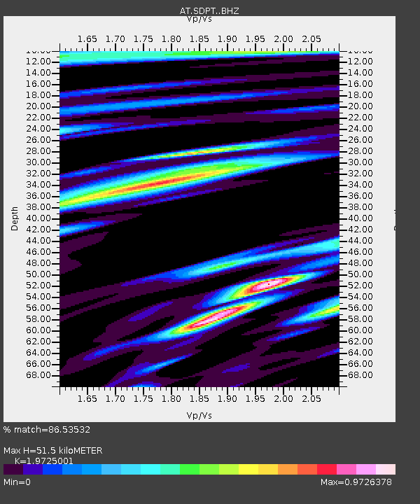
| Estimated Moho Depth: |
51.5 km |
| Estimated Crust Vp/Vs: |
1.97 |
| Assumed Crust Vp: |
5.989 km/s |
| Estimated Crust Vs: |
3.036 km/s |
| Estimated Crust Poisson's Ratio: |
0.33 |
|
| Radial Match: |
86.53532 % |
| Radial Bump: |
400 |
| Transverse Match: |
78.025185 % |
| Transverse Bump: |
400 |
| SOD ConfigId: |
29823551 |
| Insert Time: |
2023-01-23 17:52:33.854 +0000 |
| GWidth: |
2.5 |
| Max Bumps: |
400 |
| Tol: |
0.001 |
|

Signal To Noise
| Channel | StoN | STA | LTA |
| AT:SDPT: :BHZ:20230109T17:59:24.860021Z | 3.496258 | 8.7286635E-6 | 2.4965732E-6 |
| AT:SDPT: :BHN:20230109T17:59:24.860021Z | 1.055391 | 2.3550404E-6 | 2.2314389E-6 |
| AT:SDPT: :BHE:20230109T17:59:24.860021Z | 1.3011007 | 3.7942948E-6 | 2.916219E-6 |
| Arrivals |
| Ps | 8.5 SECOND |
| PpPs | 25 SECOND |
| PsPs/PpSs | 34 SECOND |


