You are here: Home > Network List > AU - Australian Seismological Centre Stations List
> Station RKGY Rocky Gully, WA > Earthquake Result Viewer
RKGY Rocky Gully, WA - Earthquake Result Viewer
| Earthquake location: |
Tanimbar Islands Reg., Indonesia |
| Earthquake latitude/longitude: |
-7.1/130.0 |
| Earthquake time(UTC): |
2023/01/09 (009) 17:47:34 GMT |
| Earthquake Depth: |
95 km |
| Earthquake Magnitude: |
7.6 mww |
| Earthquake Catalog/Contributor: |
NEIC PDE/us |
|
| Network: |
AU Australian Seismological Centre |
| Station: |
RKGY Rocky Gully, WA |
| Lat/Lon: |
34.61 S/116.98 E |
| Elevation: |
30 m |
|
| Distance: |
29.9 deg |
| Az: |
201.944 deg |
| Baz: |
26.722 deg |
| Ray Param: |
0.07939866 |
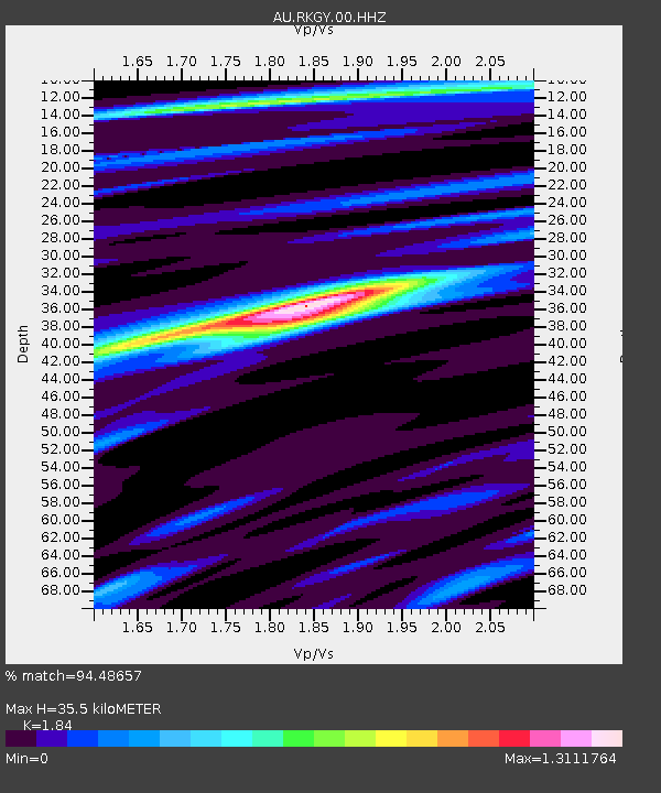
| Estimated Moho Depth: |
35.5 km |
| Estimated Crust Vp/Vs: |
1.84 |
| Assumed Crust Vp: |
6.467 km/s |
| Estimated Crust Vs: |
3.514 km/s |
| Estimated Crust Poisson's Ratio: |
0.29 |
|
| Radial Match: |
94.48657 % |
| Radial Bump: |
257 |
| Transverse Match: |
82.35632 % |
| Transverse Bump: |
400 |
| SOD ConfigId: |
29823551 |
| Insert Time: |
2023-01-23 17:52:51.239 +0000 |
| GWidth: |
2.5 |
| Max Bumps: |
400 |
| Tol: |
0.001 |
|

Signal To Noise
| Channel | StoN | STA | LTA |
| AU:RKGY:00:HHZ:20230109T17:53:03.070012Z | 10.146974 | 9.802017E-6 | 9.66004E-7 |
| AU:RKGY:00:HHN:20230109T17:53:03.070012Z | 6.0999827 | 5.5953647E-6 | 9.172755E-7 |
| AU:RKGY:00:HHE:20230109T17:53:03.070012Z | 7.0075946 | 4.752442E-6 | 6.7818445E-7 |
| Arrivals |
| Ps | 5.0 SECOND |
| PpPs | 14 SECOND |
| PsPs/PpSs | 19 SECOND |


