You are here: Home > Network List > AV - Alaska Volcano Observatory Stations List
> Station AKRB Akutan Reef Bight, Akutan Volcano, Alaska > Earthquake Result Viewer
AKRB Akutan Reef Bight, Akutan Volcano, Alaska - Earthquake Result Viewer
| Earthquake location: |
Tanimbar Islands Reg., Indonesia |
| Earthquake latitude/longitude: |
-7.1/130.0 |
| Earthquake time(UTC): |
2023/01/09 (009) 17:47:34 GMT |
| Earthquake Depth: |
95 km |
| Earthquake Magnitude: |
7.6 mww |
| Earthquake Catalog/Contributor: |
NEIC PDE/us |
|
| Network: |
AV Alaska Volcano Observatory |
| Station: |
AKRB Akutan Reef Bight, Akutan Volcano, Alaska |
| Lat/Lon: |
54.13 N/166.07 W |
| Elevation: |
334 m |
|
| Distance: |
80.9 deg |
| Az: |
32.358 deg |
| Baz: |
244.492 deg |
| Ray Param: |
0.04775313 |
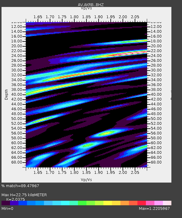
| Estimated Moho Depth: |
22.75 km |
| Estimated Crust Vp/Vs: |
2.04 |
| Assumed Crust Vp: |
5.989 km/s |
| Estimated Crust Vs: |
2.939 km/s |
| Estimated Crust Poisson's Ratio: |
0.34 |
|
| Radial Match: |
89.47967 % |
| Radial Bump: |
400 |
| Transverse Match: |
77.37763 % |
| Transverse Bump: |
400 |
| SOD ConfigId: |
29823551 |
| Insert Time: |
2023-01-23 17:53:08.012 +0000 |
| GWidth: |
2.5 |
| Max Bumps: |
400 |
| Tol: |
0.001 |
|

Signal To Noise
| Channel | StoN | STA | LTA |
| AV:AKRB: :BHZ:20230109T17:59:06.998998Z | 4.6454268 | 7.585016E-6 | 1.6327922E-6 |
| AV:AKRB: :BHN:20230109T17:59:06.998998Z | 2.0018516 | 4.5000825E-6 | 2.24796E-6 |
| AV:AKRB: :BHE:20230109T17:59:06.998998Z | 0.75402385 | 2.8281527E-6 | 3.750747E-6 |
| Arrivals |
| Ps | 4.0 SECOND |
| PpPs | 11 SECOND |
| PsPs/PpSs | 15 SECOND |


