You are here: Home > Network List > AV - Alaska Volcano Observatory Stations List
> Station GAKI Kavalga Island, Gareloi Volcano, Alaska > Earthquake Result Viewer
GAKI Kavalga Island, Gareloi Volcano, Alaska - Earthquake Result Viewer
| Earthquake location: |
Tanimbar Islands Reg., Indonesia |
| Earthquake latitude/longitude: |
-7.1/130.0 |
| Earthquake time(UTC): |
2023/01/09 (009) 17:47:34 GMT |
| Earthquake Depth: |
95 km |
| Earthquake Magnitude: |
7.6 mww |
| Earthquake Catalog/Contributor: |
NEIC PDE/us |
|
| Network: |
AV Alaska Volcano Observatory |
| Station: |
GAKI Kavalga Island, Gareloi Volcano, Alaska |
| Lat/Lon: |
51.55 N/178.81 W |
| Elevation: |
99 m |
|
| Distance: |
73.0 deg |
| Az: |
30.566 deg |
| Baz: |
233.937 deg |
| Ray Param: |
0.053093452 |
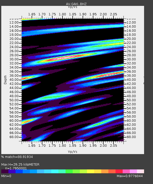
| Estimated Moho Depth: |
29.25 km |
| Estimated Crust Vp/Vs: |
1.80 |
| Assumed Crust Vp: |
6.048 km/s |
| Estimated Crust Vs: |
3.369 km/s |
| Estimated Crust Poisson's Ratio: |
0.27 |
|
| Radial Match: |
88.91934 % |
| Radial Bump: |
400 |
| Transverse Match: |
81.74257 % |
| Transverse Bump: |
400 |
| SOD ConfigId: |
29823551 |
| Insert Time: |
2023-01-23 17:53:52.844 +0000 |
| GWidth: |
2.5 |
| Max Bumps: |
400 |
| Tol: |
0.001 |
|

Signal To Noise
| Channel | StoN | STA | LTA |
| AV:GAKI: :BHZ:20230109T17:58:22.579992Z | 2.4661186 | 4.4947983E-6 | 1.8226206E-6 |
| AV:GAKI: :BHN:20230109T17:58:22.579992Z | 0.95977175 | 1.7715556E-6 | 1.8458093E-6 |
| AV:GAKI: :BHE:20230109T17:58:22.579992Z | 1.2862251 | 2.4453354E-6 | 1.9011723E-6 |
| Arrivals |
| Ps | 4.0 SECOND |
| PpPs | 13 SECOND |
| PsPs/PpSs | 17 SECOND |


