You are here: Home > Network List > AV - Alaska Volcano Observatory Stations List
> Station ILSW Iliamna Southwest, Iliamna Volcano, Alaska > Earthquake Result Viewer
ILSW Iliamna Southwest, Iliamna Volcano, Alaska - Earthquake Result Viewer
| Earthquake location: |
Tanimbar Islands Reg., Indonesia |
| Earthquake latitude/longitude: |
-7.1/130.0 |
| Earthquake time(UTC): |
2023/01/09 (009) 17:47:34 GMT |
| Earthquake Depth: |
95 km |
| Earthquake Magnitude: |
7.6 mww |
| Earthquake Catalog/Contributor: |
NEIC PDE/us |
|
| Network: |
AV Alaska Volcano Observatory |
| Station: |
ILSW Iliamna Southwest, Iliamna Volcano, Alaska |
| Lat/Lon: |
59.98 N/153.14 W |
| Elevation: |
1318 m |
|
| Distance: |
89.5 deg |
| Az: |
29.311 deg |
| Baz: |
255.093 deg |
| Ray Param: |
0.04173124 |
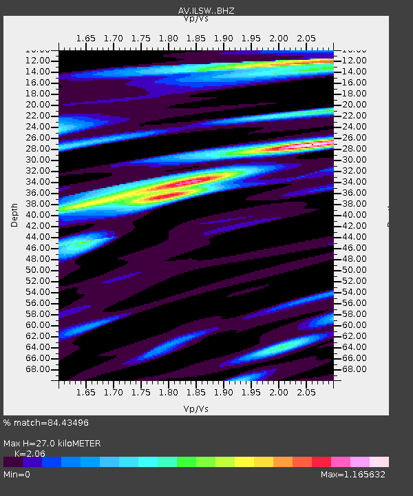
| Estimated Moho Depth: |
27.0 km |
| Estimated Crust Vp/Vs: |
2.06 |
| Assumed Crust Vp: |
5.989 km/s |
| Estimated Crust Vs: |
2.907 km/s |
| Estimated Crust Poisson's Ratio: |
0.35 |
|
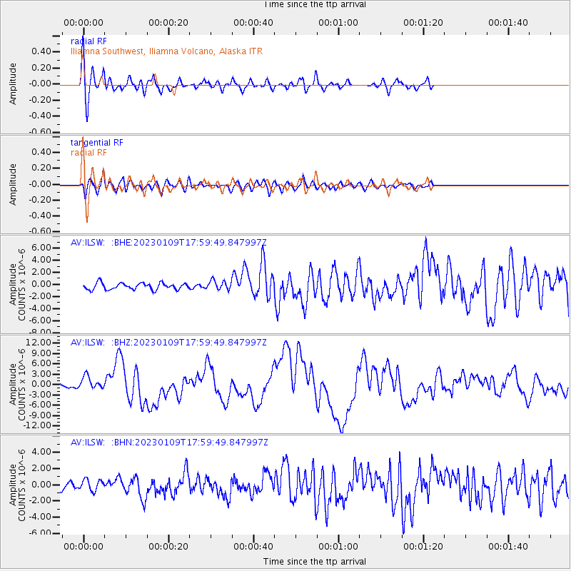
| Radial Match: |
84.43496 % |
| Radial Bump: |
400 |
| Transverse Match: |
77.18131 % |
| Transverse Bump: |
400 |
| SOD ConfigId: |
29823551 |
| Insert Time: |
2023-01-23 17:54:13.687 +0000 |
| GWidth: |
2.5 |
| Max Bumps: |
400 |
| Tol: |
0.001 |
|
Signal To Noise
| Channel | StoN | STA | LTA |
| AV:ILSW: :BHZ:20230109T17:59:49.847997Z | 2.8743756 | 1.9327697E-6 | 6.724138E-7 |
| AV:ILSW: :BHN:20230109T17:59:49.847997Z | 0.87782055 | 6.935673E-7 | 7.9010147E-7 |
| AV:ILSW: :BHE:20230109T17:59:49.847997Z | 1.4280959 | 7.748464E-7 | 5.4257305E-7 |
| Arrivals |
| Ps | 4.9 SECOND |
| PpPs | 14 SECOND |
| PsPs/PpSs | 18 SECOND |


