You are here: Home > Network List > AV - Alaska Volcano Observatory Stations List
> Station KIRH Round Head, Kanaga Volcano, Alaska > Earthquake Result Viewer
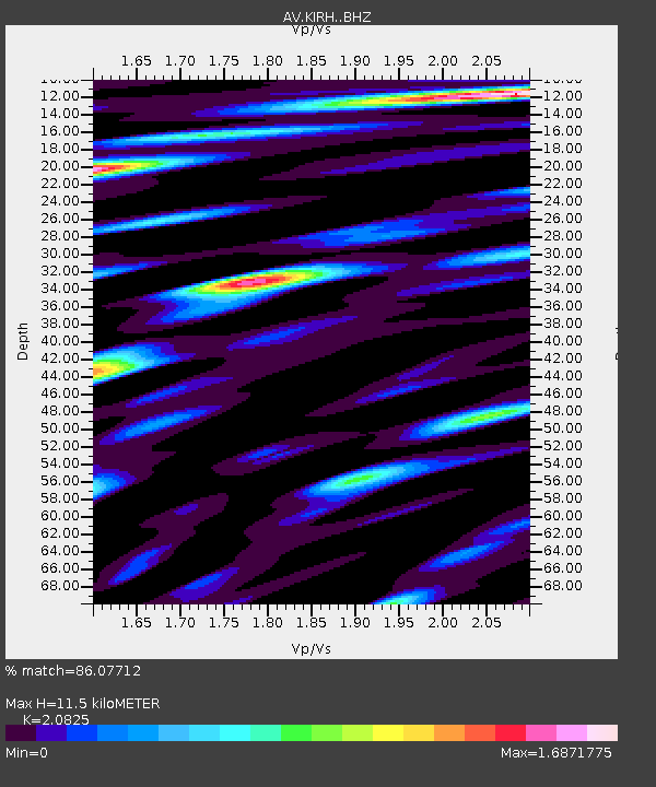
KIRH Round Head, Kanaga Volcano, Alaska - Earthquake Result Viewer
| Earthquake location: |
Tanimbar Islands Reg., Indonesia |
| Earthquake latitude/longitude: |
-7.1/130.0 |
| Earthquake time(UTC): |
2023/01/09 (009) 17:47:34 GMT |
| Earthquake Depth: |
95 km |
| Earthquake Magnitude: |
7.6 mww |
| Earthquake Catalog/Contributor: |
NEIC PDE/us |
|
| Network: |
AV Alaska Volcano Observatory |
| Station: |
KIRH Round Head, Kanaga Volcano, Alaska |
| Lat/Lon: |
51.90 N/177.09 W |
| Elevation: |
321 m |
|
| Distance: |
74.0 deg |
| Az: |
30.916 deg |
| Baz: |
235.383 deg |
| Ray Param: |
0.052390862 |
| Estimated Moho Depth: |
11.5 km |
| Estimated Crust Vp/Vs: |
2.08 |
| Assumed Crust Vp: |
5.88 km/s |
| Estimated Crust Vs: |
2.824 km/s |
| Estimated Crust Poisson's Ratio: |
0.35 |
|
| Radial Match: |
86.07712 % |
| Radial Bump: |
400 |
| Transverse Match: |
78.50371 % |
| Transverse Bump: |
400 |
| SOD ConfigId: |
29823551 |
| Insert Time: |
2023-01-23 17:54:37.676 +0000 |
| GWidth: |
2.5 |
| Max Bumps: |
400 |
| Tol: |
0.001 |
|

Signal To Noise
| Channel | StoN | STA | LTA |
| AV:KIRH: :BHZ:20230109T17:58:28.839025Z | 2.0157602 | 6.1204278E-6 | 3.0362876E-6 |
| AV:KIRH: :BHN:20230109T17:58:28.839025Z | 1.9125743 | 5.1925053E-6 | 2.7149301E-6 |
| AV:KIRH: :BHE:20230109T17:58:28.839025Z | 0.9090183 | 2.7652675E-6 | 3.0420372E-6 |
| Arrivals |
| Ps | 2.2 SECOND |
| PpPs | 5.9 SECOND |
| PsPs/PpSs | 8.1 SECOND |


