You are here: Home > Network List > AV - Alaska Volcano Observatory Stations List
> Station KOKV Korovin Volcano, Korovin Volcano, Alaska > Earthquake Result Viewer
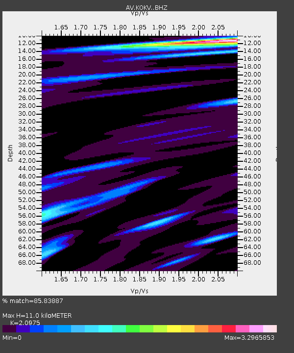
KOKV Korovin Volcano, Korovin Volcano, Alaska - Earthquake Result Viewer
| Earthquake location: |
Tanimbar Islands Reg., Indonesia |
| Earthquake latitude/longitude: |
-7.1/130.0 |
| Earthquake time(UTC): |
2023/01/09 (009) 17:47:34 GMT |
| Earthquake Depth: |
95 km |
| Earthquake Magnitude: |
7.6 mww |
| Earthquake Catalog/Contributor: |
NEIC PDE/us |
|
| Network: |
AV Alaska Volcano Observatory |
| Station: |
KOKV Korovin Volcano, Korovin Volcano, Alaska |
| Lat/Lon: |
52.36 N/174.17 W |
| Elevation: |
776 m |
|
| Distance: |
75.8 deg |
| Az: |
31.546 deg |
| Baz: |
237.851 deg |
| Ray Param: |
0.051208265 |
| Estimated Moho Depth: |
11.0 km |
| Estimated Crust Vp/Vs: |
2.10 |
| Assumed Crust Vp: |
5.88 km/s |
| Estimated Crust Vs: |
2.804 km/s |
| Estimated Crust Poisson's Ratio: |
0.35 |
|
| Radial Match: |
85.83887 % |
| Radial Bump: |
400 |
| Transverse Match: |
86.60347 % |
| Transverse Bump: |
400 |
| SOD ConfigId: |
29823551 |
| Insert Time: |
2023-01-23 17:54:44.535 +0000 |
| GWidth: |
2.5 |
| Max Bumps: |
400 |
| Tol: |
0.001 |
|

Signal To Noise
| Channel | StoN | STA | LTA |
| AV:KOKV: :BHZ:20230109T17:58:38.939977Z | 3.6002023 | 7.0073747E-6 | 1.9463837E-6 |
| AV:KOKV: :BHN:20230109T17:58:38.939977Z | 1.097119 | 3.7508548E-6 | 3.4188224E-6 |
| AV:KOKV: :BHE:20230109T17:58:38.939977Z | 1.18496 | 3.9401675E-6 | 3.3251483E-6 |
| Arrivals |
| Ps | 2.1 SECOND |
| PpPs | 5.7 SECOND |
| PsPs/PpSs | 7.8 SECOND |


