You are here: Home > Network List > AV - Alaska Volcano Observatory Stations List
> Station KVT Katmai Valley of 10,000 Smokes, Alaska > Earthquake Result Viewer
KVT Katmai Valley of 10,000 Smokes, Alaska - Earthquake Result Viewer
| Earthquake location: |
Tanimbar Islands Reg., Indonesia |
| Earthquake latitude/longitude: |
-7.1/130.0 |
| Earthquake time(UTC): |
2023/01/09 (009) 17:47:34 GMT |
| Earthquake Depth: |
95 km |
| Earthquake Magnitude: |
7.6 mww |
| Earthquake Catalog/Contributor: |
NEIC PDE/us |
|
| Network: |
AV Alaska Volcano Observatory |
| Station: |
KVT Katmai Valley of 10,000 Smokes, Alaska |
| Lat/Lon: |
58.38 N/155.30 W |
| Elevation: |
457 m |
|
| Distance: |
88.0 deg |
| Az: |
30.555 deg |
| Baz: |
253.272 deg |
| Ray Param: |
0.042685043 |
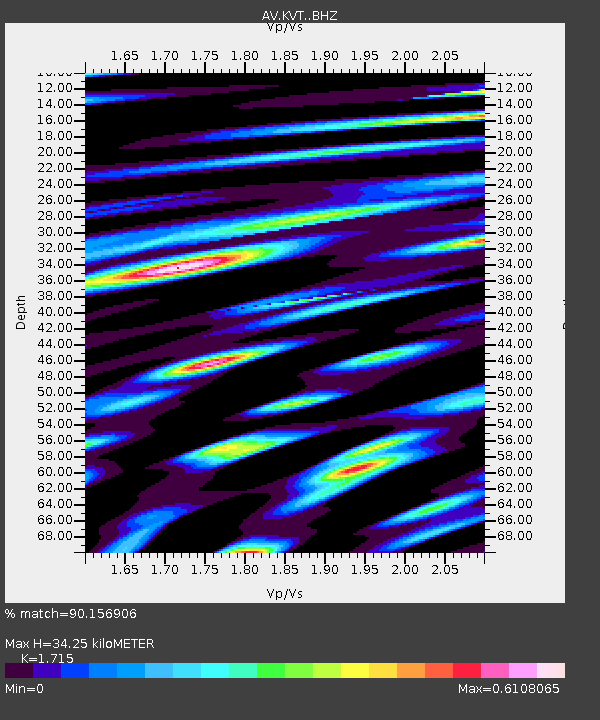
| Estimated Moho Depth: |
34.25 km |
| Estimated Crust Vp/Vs: |
1.72 |
| Assumed Crust Vp: |
6.438 km/s |
| Estimated Crust Vs: |
3.754 km/s |
| Estimated Crust Poisson's Ratio: |
0.24 |
|
| Radial Match: |
90.156906 % |
| Radial Bump: |
400 |
| Transverse Match: |
87.74485 % |
| Transverse Bump: |
400 |
| SOD ConfigId: |
29823551 |
| Insert Time: |
2023-01-23 17:54:53.752 +0000 |
| GWidth: |
2.5 |
| Max Bumps: |
400 |
| Tol: |
0.001 |
|

Signal To Noise
| Channel | StoN | STA | LTA |
| AV:KVT: :BHZ:20230109T17:59:42.798986Z | 2.1206305 | 3.278989E-6 | 1.5462331E-6 |
| AV:KVT: :BHN:20230109T17:59:42.798986Z | 1.9177924 | 1.0762609E-6 | 5.611978E-7 |
| AV:KVT: :BHE:20230109T17:59:42.798986Z | 2.94664 | 1.4869971E-6 | 5.046416E-7 |
| Arrivals |
| Ps | 3.9 SECOND |
| PpPs | 14 SECOND |
| PsPs/PpSs | 18 SECOND |


