You are here: Home > Network List > AV - Alaska Volcano Observatory Stations List
> Station MAPS Pakushin Southeast, Makushin Volcano, Alaska > Earthquake Result Viewer
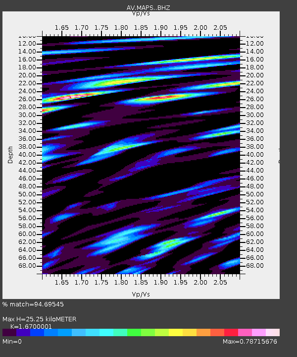
MAPS Pakushin Southeast, Makushin Volcano, Alaska - Earthquake Result Viewer
| Earthquake location: |
Tanimbar Islands Reg., Indonesia |
| Earthquake latitude/longitude: |
-7.1/130.0 |
| Earthquake time(UTC): |
2023/01/09 (009) 17:47:34 GMT |
| Earthquake Depth: |
95 km |
| Earthquake Magnitude: |
7.6 mww |
| Earthquake Catalog/Contributor: |
NEIC PDE/us |
|
| Network: |
AV Alaska Volcano Observatory |
| Station: |
MAPS Pakushin Southeast, Makushin Volcano, Alaska |
| Lat/Lon: |
53.81 N/166.94 W |
| Elevation: |
333 m |
|
| Distance: |
80.3 deg |
| Az: |
32.424 deg |
| Baz: |
243.8 deg |
| Ray Param: |
0.048161574 |
| Estimated Moho Depth: |
25.25 km |
| Estimated Crust Vp/Vs: |
1.67 |
| Assumed Crust Vp: |
3.943 km/s |
| Estimated Crust Vs: |
2.361 km/s |
| Estimated Crust Poisson's Ratio: |
0.22 |
|
| Radial Match: |
94.69545 % |
| Radial Bump: |
400 |
| Transverse Match: |
83.54026 % |
| Transverse Bump: |
400 |
| SOD ConfigId: |
29823551 |
| Insert Time: |
2023-01-23 17:54:59.288 +0000 |
| GWidth: |
2.5 |
| Max Bumps: |
400 |
| Tol: |
0.001 |
|

Signal To Noise
| Channel | StoN | STA | LTA |
| AV:MAPS: :BHZ:20230109T17:59:03.780004Z | 5.437499 | 6.399892E-6 | 1.1769918E-6 |
| AV:MAPS: :BHN:20230109T17:59:03.780004Z | 1.3265629 | 2.2718398E-6 | 1.7125761E-6 |
| AV:MAPS: :BHE:20230109T17:59:03.780004Z | 3.3300927 | 3.6503407E-6 | 1.0961679E-6 |
| Arrivals |
| Ps | 4.3 SECOND |
| PpPs | 17 SECOND |
| PsPs/PpSs | 21 SECOND |


