You are here: Home > Network List > AV - Alaska Volcano Observatory Stations List
> Station OKTU Mount Tulik, Okmok Caldera, Alaska > Earthquake Result Viewer
OKTU Mount Tulik, Okmok Caldera, Alaska - Earthquake Result Viewer
| Earthquake location: |
Tanimbar Islands Reg., Indonesia |
| Earthquake latitude/longitude: |
-7.1/130.0 |
| Earthquake time(UTC): |
2023/01/09 (009) 17:47:34 GMT |
| Earthquake Depth: |
95 km |
| Earthquake Magnitude: |
7.6 mww |
| Earthquake Catalog/Contributor: |
NEIC PDE/us |
|
| Network: |
AV Alaska Volcano Observatory |
| Station: |
OKTU Mount Tulik, Okmok Caldera, Alaska |
| Lat/Lon: |
53.38 N/168.04 W |
| Elevation: |
646 m |
|
| Distance: |
79.5 deg |
| Az: |
32.512 deg |
| Baz: |
242.931 deg |
| Ray Param: |
0.048692994 |
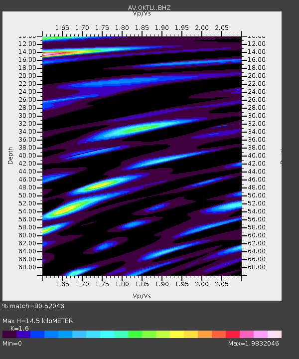
| Estimated Moho Depth: |
14.5 km |
| Estimated Crust Vp/Vs: |
1.60 |
| Assumed Crust Vp: |
5.88 km/s |
| Estimated Crust Vs: |
3.675 km/s |
| Estimated Crust Poisson's Ratio: |
0.18 |
|
| Radial Match: |
80.52046 % |
| Radial Bump: |
400 |
| Transverse Match: |
72.71762 % |
| Transverse Bump: |
400 |
| SOD ConfigId: |
29823551 |
| Insert Time: |
2023-01-23 17:55:26.313 +0000 |
| GWidth: |
2.5 |
| Max Bumps: |
400 |
| Tol: |
0.001 |
|

Signal To Noise
| Channel | StoN | STA | LTA |
| AV:OKTU: :BHZ:20230109T17:58:59.61997Z | 3.3797154 | 7.4263253E-6 | 2.1973226E-6 |
| AV:OKTU: :BHN:20230109T17:58:59.61997Z | 0.96192175 | 3.5885919E-6 | 3.7306484E-6 |
| AV:OKTU: :BHE:20230109T17:58:59.61997Z | 1.4861153 | 3.367115E-6 | 2.265716E-6 |
| Arrivals |
| Ps | 1.5 SECOND |
| PpPs | 6.2 SECOND |
| PsPs/PpSs | 7.8 SECOND |


