You are here: Home > Network List > AV - Alaska Volcano Observatory Stations List
> Station TASO South, Tanaga Volcano, Alaska > Earthquake Result Viewer
TASO South, Tanaga Volcano, Alaska - Earthquake Result Viewer
| Earthquake location: |
Tanimbar Islands Reg., Indonesia |
| Earthquake latitude/longitude: |
-7.1/130.0 |
| Earthquake time(UTC): |
2023/01/09 (009) 17:47:34 GMT |
| Earthquake Depth: |
95 km |
| Earthquake Magnitude: |
7.6 mww |
| Earthquake Catalog/Contributor: |
NEIC PDE/us |
|
| Network: |
AV Alaska Volcano Observatory |
| Station: |
TASO South, Tanaga Volcano, Alaska |
| Lat/Lon: |
51.85 N/178.15 W |
| Elevation: |
690 m |
|
| Distance: |
73.5 deg |
| Az: |
30.566 deg |
| Baz: |
234.46 deg |
| Ray Param: |
0.052762058 |
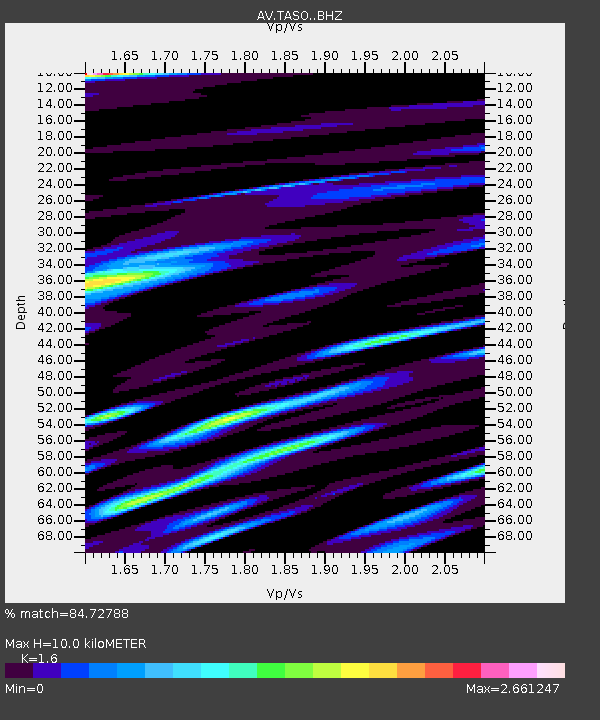
| Estimated Moho Depth: |
10.0 km |
| Estimated Crust Vp/Vs: |
1.60 |
| Assumed Crust Vp: |
6.048 km/s |
| Estimated Crust Vs: |
3.78 km/s |
| Estimated Crust Poisson's Ratio: |
0.18 |
|
| Radial Match: |
84.72788 % |
| Radial Bump: |
400 |
| Transverse Match: |
80.34827 % |
| Transverse Bump: |
400 |
| SOD ConfigId: |
29823551 |
| Insert Time: |
2023-01-23 17:56:11.578 +0000 |
| GWidth: |
2.5 |
| Max Bumps: |
400 |
| Tol: |
0.001 |
|

Signal To Noise
| Channel | StoN | STA | LTA |
| AV:TASO: :BHZ:20230109T17:58:25.579992Z | 5.0148716 | 7.6149117E-6 | 1.518466E-6 |
| AV:TASO: :BHN:20230109T17:58:25.579992Z | 0.91957736 | 3.4439256E-6 | 3.745118E-6 |
| AV:TASO: :BHE:20230109T17:58:25.579992Z | 1.0718205 | 4.3414034E-6 | 4.0504947E-6 |
| Arrivals |
| Ps | 1.0 SECOND |
| PpPs | 4.2 SECOND |
| PsPs/PpSs | 5.2 SECOND |


