You are here: Home > Network List > AV - Alaska Volcano Observatory Stations List
> Station WESE Southeast, Westdahl Peak, Alaska > Earthquake Result Viewer
WESE Southeast, Westdahl Peak, Alaska - Earthquake Result Viewer
| Earthquake location: |
Tanimbar Islands Reg., Indonesia |
| Earthquake latitude/longitude: |
-7.1/130.0 |
| Earthquake time(UTC): |
2023/01/09 (009) 17:47:34 GMT |
| Earthquake Depth: |
95 km |
| Earthquake Magnitude: |
7.6 mww |
| Earthquake Catalog/Contributor: |
NEIC PDE/us |
|
| Network: |
AV Alaska Volcano Observatory |
| Station: |
WESE Southeast, Westdahl Peak, Alaska |
| Lat/Lon: |
54.47 N/164.59 W |
| Elevation: |
953 m |
|
| Distance: |
81.8 deg |
| Az: |
32.413 deg |
| Baz: |
245.703 deg |
| Ray Param: |
0.04709768 |
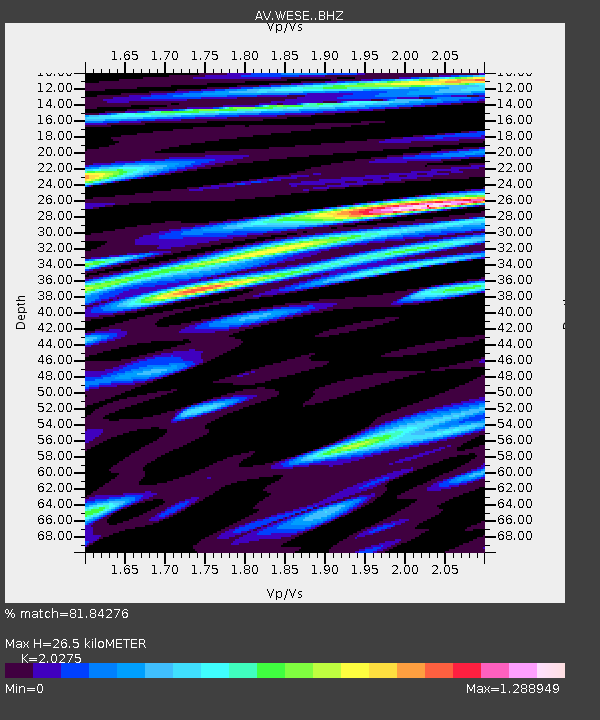
| Estimated Moho Depth: |
26.5 km |
| Estimated Crust Vp/Vs: |
2.03 |
| Assumed Crust Vp: |
5.989 km/s |
| Estimated Crust Vs: |
2.954 km/s |
| Estimated Crust Poisson's Ratio: |
0.34 |
|
| Radial Match: |
81.84276 % |
| Radial Bump: |
400 |
| Transverse Match: |
77.60971 % |
| Transverse Bump: |
400 |
| SOD ConfigId: |
29823551 |
| Insert Time: |
2023-01-23 17:56:26.380 +0000 |
| GWidth: |
2.5 |
| Max Bumps: |
400 |
| Tol: |
0.001 |
|

Signal To Noise
| Channel | StoN | STA | LTA |
| AV:WESE: :BHZ:20230109T17:59:11.899999Z | 2.9377794 | 7.1521386E-6 | 2.4345388E-6 |
| AV:WESE: :BHN:20230109T17:59:11.899999Z | 1.5694073 | 5.5477194E-6 | 3.5349135E-6 |
| AV:WESE: :BHE:20230109T17:59:11.899999Z | 1.60266 | 3.4764882E-6 | 2.1691988E-6 |
| Arrivals |
| Ps | 4.6 SECOND |
| PpPs | 13 SECOND |
| PsPs/PpSs | 18 SECOND |


