You are here: Home > Network List > EO - EON-ROSE () Stations List
> Station KLRS Kluane Lake Research Station > Earthquake Result Viewer
KLRS Kluane Lake Research Station - Earthquake Result Viewer
| Earthquake location: |
Tanimbar Islands Reg., Indonesia |
| Earthquake latitude/longitude: |
-7.1/130.0 |
| Earthquake time(UTC): |
2023/01/09 (009) 17:47:34 GMT |
| Earthquake Depth: |
95 km |
| Earthquake Magnitude: |
7.6 mww |
| Earthquake Catalog/Contributor: |
NEIC PDE/us |
|
| Network: |
EO EON-ROSE () |
| Station: |
KLRS Kluane Lake Research Station |
| Lat/Lon: |
61.03 N/138.41 W |
| Elevation: |
795 m |
|
| Distance: |
96.9 deg |
| Az: |
29.354 deg |
| Baz: |
267.914 deg |
| Ray Param: |
0.04030634 |
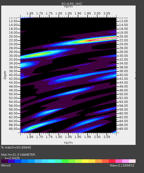
| Estimated Moho Depth: |
21.0 km |
| Estimated Crust Vp/Vs: |
2.04 |
| Assumed Crust Vp: |
6.566 km/s |
| Estimated Crust Vs: |
3.215 km/s |
| Estimated Crust Poisson's Ratio: |
0.34 |
|
| Radial Match: |
83.65648 % |
| Radial Bump: |
400 |
| Transverse Match: |
78.45066 % |
| Transverse Bump: |
400 |
| SOD ConfigId: |
29823551 |
| Insert Time: |
2023-01-23 17:56:56.453 +0000 |
| GWidth: |
2.5 |
| Max Bumps: |
400 |
| Tol: |
0.001 |
|

Signal To Noise
| Channel | StoN | STA | LTA |
| EO:KLRS: :HHZ:20230109T18:00:23.430028Z | 2.8326938 | 1.1028104E-6 | 3.8931506E-7 |
| EO:KLRS: :HHN:20230109T18:00:23.430028Z | 0.63790035 | 2.78637E-7 | 4.3680333E-7 |
| EO:KLRS: :HHE:20230109T18:00:23.430028Z | 0.86489147 | 4.0536105E-7 | 4.6868428E-7 |
| Arrivals |
| Ps | 3.4 SECOND |
| PpPs | 9.6 SECOND |
| PsPs/PpSs | 13 SECOND |


