You are here: Home > Network List > G - GEOSCOPE Stations List
> Station DRV Dumont d'Urville, Terre Adelie (Antartica) > Earthquake Result Viewer
DRV Dumont d'Urville, Terre Adelie (Antartica) - Earthquake Result Viewer
| Earthquake location: |
Tanimbar Islands Reg., Indonesia |
| Earthquake latitude/longitude: |
-7.1/130.0 |
| Earthquake time(UTC): |
2023/01/09 (009) 17:47:34 GMT |
| Earthquake Depth: |
95 km |
| Earthquake Magnitude: |
7.6 mww |
| Earthquake Catalog/Contributor: |
NEIC PDE/us |
|
| Network: |
G GEOSCOPE |
| Station: |
DRV Dumont d'Urville, Terre Adelie (Antartica) |
| Lat/Lon: |
66.67 S/140.01 E |
| Elevation: |
40 m |
|
| Distance: |
59.9 deg |
| Az: |
175.426 deg |
| Baz: |
348.541 deg |
| Ray Param: |
0.06163475 |
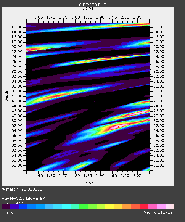
| Estimated Moho Depth: |
52.0 km |
| Estimated Crust Vp/Vs: |
1.97 |
| Assumed Crust Vp: |
6.39 km/s |
| Estimated Crust Vs: |
3.239 km/s |
| Estimated Crust Poisson's Ratio: |
0.33 |
|
| Radial Match: |
96.320885 % |
| Radial Bump: |
339 |
| Transverse Match: |
91.125175 % |
| Transverse Bump: |
400 |
| SOD ConfigId: |
29823551 |
| Insert Time: |
2023-01-23 17:57:06.238 +0000 |
| GWidth: |
2.5 |
| Max Bumps: |
400 |
| Tol: |
0.001 |
|
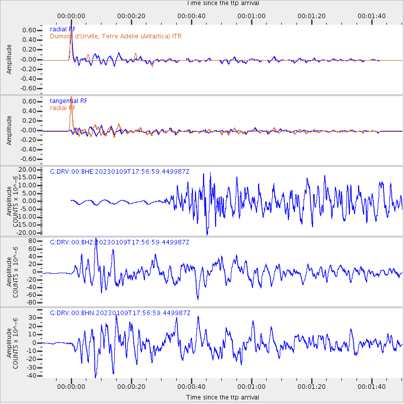
Signal To Noise
| Channel | StoN | STA | LTA |
| G:DRV:00:BHZ:20230109T17:56:59.449987Z | 17.824945 | 1.5695055E-5 | 8.8051064E-7 |
| G:DRV:00:BHN:20230109T17:56:59.449987Z | 12.051715 | 7.734663E-6 | 6.417894E-7 |
| G:DRV:00:BHE:20230109T17:56:59.449987Z | 2.0401325 | 1.8065675E-6 | 8.8551485E-7 |
| Arrivals |
| Ps | 8.2 SECOND |
| PpPs | 23 SECOND |
| PsPs/PpSs | 31 SECOND |


