You are here: Home > Network List > G - GEOSCOPE Stations List
> Station INU Inuyama, Japan > Earthquake Result Viewer
INU Inuyama, Japan - Earthquake Result Viewer
| Earthquake location: |
Tanimbar Islands Reg., Indonesia |
| Earthquake latitude/longitude: |
-7.1/130.0 |
| Earthquake time(UTC): |
2023/01/09 (009) 17:47:34 GMT |
| Earthquake Depth: |
95 km |
| Earthquake Magnitude: |
7.6 mww |
| Earthquake Catalog/Contributor: |
NEIC PDE/us |
|
| Network: |
G GEOSCOPE |
| Station: |
INU Inuyama, Japan |
| Lat/Lon: |
35.35 N/137.03 E |
| Elevation: |
132 m |
|
| Distance: |
42.7 deg |
| Az: |
8.432 deg |
| Baz: |
190.255 deg |
| Ray Param: |
0.07268621 |
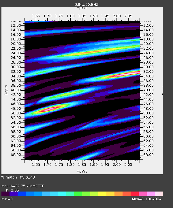
| Estimated Moho Depth: |
32.75 km |
| Estimated Crust Vp/Vs: |
2.05 |
| Assumed Crust Vp: |
6.461 km/s |
| Estimated Crust Vs: |
3.152 km/s |
| Estimated Crust Poisson's Ratio: |
0.34 |
|
| Radial Match: |
95.0148 % |
| Radial Bump: |
400 |
| Transverse Match: |
82.61602 % |
| Transverse Bump: |
400 |
| SOD ConfigId: |
29823551 |
| Insert Time: |
2023-01-23 17:57:12.100 +0000 |
| GWidth: |
2.5 |
| Max Bumps: |
400 |
| Tol: |
0.001 |
|
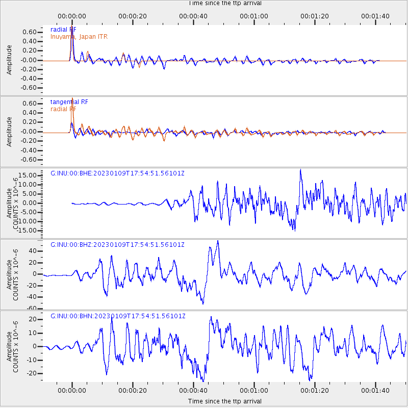
Signal To Noise
| Channel | StoN | STA | LTA |
| G:INU:00:BHZ:20230109T17:54:51.56101Z | 7.503349 | 5.0640533E-6 | 6.749058E-7 |
| G:INU:00:BHN:20230109T17:54:51.56101Z | 3.1122754 | 2.501928E-6 | 8.038904E-7 |
| G:INU:00:BHE:20230109T17:54:51.56101Z | 4.2903857 | 1.5754748E-6 | 3.6721053E-7 |
| Arrivals |
| Ps | 5.6 SECOND |
| PpPs | 15 SECOND |
| PsPs/PpSs | 20 SECOND |


