You are here: Home > Network List > G - GEOSCOPE Stations List
> Station PAF Port aux Francais, Kerguelen (South Indian Ocean) > Earthquake Result Viewer
PAF Port aux Francais, Kerguelen (South Indian Ocean) - Earthquake Result Viewer
| Earthquake location: |
Tanimbar Islands Reg., Indonesia |
| Earthquake latitude/longitude: |
-7.1/130.0 |
| Earthquake time(UTC): |
2023/01/09 (009) 17:47:34 GMT |
| Earthquake Depth: |
95 km |
| Earthquake Magnitude: |
7.6 mww |
| Earthquake Catalog/Contributor: |
NEIC PDE/us |
|
| Network: |
G GEOSCOPE |
| Station: |
PAF Port aux Francais, Kerguelen (South Indian Ocean) |
| Lat/Lon: |
49.35 S/70.21 E |
| Elevation: |
17 m |
|
| Distance: |
65.2 deg |
| Az: |
218.506 deg |
| Baz: |
70.89 deg |
| Ray Param: |
0.058150526 |
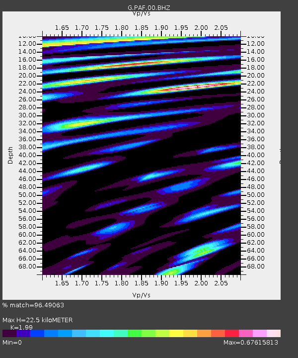
| Estimated Moho Depth: |
22.5 km |
| Estimated Crust Vp/Vs: |
1.99 |
| Assumed Crust Vp: |
4.73 km/s |
| Estimated Crust Vs: |
2.377 km/s |
| Estimated Crust Poisson's Ratio: |
0.33 |
|
| Radial Match: |
96.49063 % |
| Radial Bump: |
400 |
| Transverse Match: |
90.222374 % |
| Transverse Bump: |
400 |
| SOD ConfigId: |
29823551 |
| Insert Time: |
2023-01-23 17:57:14.150 +0000 |
| GWidth: |
2.5 |
| Max Bumps: |
400 |
| Tol: |
0.001 |
|

Signal To Noise
| Channel | StoN | STA | LTA |
| G:PAF:00:BHZ:20230109T17:57:34.949987Z | 2.8492837 | 7.1741824E-6 | 2.5178897E-6 |
| G:PAF:00:BHN:20230109T17:57:34.949987Z | 1.4351755 | 1.510906E-6 | 1.0527674E-6 |
| G:PAF:00:BHE:20230109T17:57:34.949987Z | 2.8843412 | 3.3179526E-6 | 1.1503329E-6 |
| Arrivals |
| Ps | 4.8 SECOND |
| PpPs | 14 SECOND |
| PsPs/PpSs | 19 SECOND |


