You are here: Home > Network List > G - GEOSCOPE Stations List
> Station RER Riviere de l'Est, La Reunion (Indian Ocean) > Earthquake Result Viewer
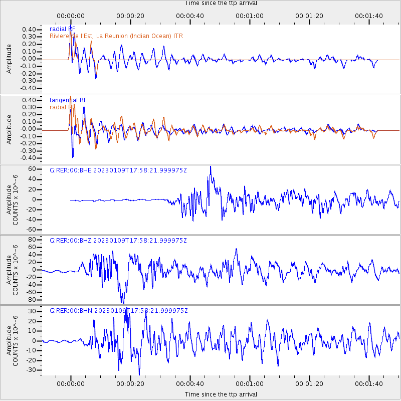
RER Riviere de l'Est, La Reunion (Indian Ocean) - Earthquake Result Viewer
*The percent match for this event was below the threshold and hence no stack was calculated.
| Earthquake location: |
Tanimbar Islands Reg., Indonesia |
| Earthquake latitude/longitude: |
-7.1/130.0 |
| Earthquake time(UTC): |
2023/01/09 (009) 17:47:34 GMT |
| Earthquake Depth: |
95 km |
| Earthquake Magnitude: |
7.6 mww |
| Earthquake Catalog/Contributor: |
NEIC PDE/us |
|
| Network: |
G GEOSCOPE |
| Station: |
RER Riviere de l'Est, La Reunion (Indian Ocean) |
| Lat/Lon: |
21.16 S/55.75 E |
| Elevation: |
834 m |
|
| Distance: |
72.9 deg |
| Az: |
250.105 deg |
| Baz: |
91.077 deg |
| Ray Param: |
$rayparam |
*The percent match for this event was below the threshold and hence was not used in the summary stack. |
|
| Radial Match: |
83.32516 % |
| Radial Bump: |
400 |
| Transverse Match: |
86.436516 % |
| Transverse Bump: |
400 |
| SOD ConfigId: |
29823551 |
| Insert Time: |
2023-01-23 17:57:17.521 +0000 |
| GWidth: |
2.5 |
| Max Bumps: |
400 |
| Tol: |
0.001 |
|
Signal To Noise
| Channel | StoN | STA | LTA |
| G:RER:00:BHZ:20230109T17:58:21.999975Z | 6.1010394 | 8.392154E-6 | 1.3755285E-6 |
| G:RER:00:BHN:20230109T17:58:21.999975Z | 2.5783014 | 1.4994254E-6 | 5.815555E-7 |
| G:RER:00:BHE:20230109T17:58:21.999975Z | 3.9398322 | 3.5085484E-6 | 8.905324E-7 |
| Arrivals |
| Ps | |
| PpPs | |
| PsPs/PpSs | |


