You are here: Home > Network List > G - GEOSCOPE Stations List
> Station ROCAM Leguat Reserve, Rodrigues Island, Republic of Mauritius > Earthquake Result Viewer
ROCAM Leguat Reserve, Rodrigues Island, Republic of Mauritius - Earthquake Result Viewer
| Earthquake location: |
Tanimbar Islands Reg., Indonesia |
| Earthquake latitude/longitude: |
-7.1/130.0 |
| Earthquake time(UTC): |
2023/01/09 (009) 17:47:34 GMT |
| Earthquake Depth: |
95 km |
| Earthquake Magnitude: |
7.6 mww |
| Earthquake Catalog/Contributor: |
NEIC PDE/us |
|
| Network: |
G GEOSCOPE |
| Station: |
ROCAM Leguat Reserve, Rodrigues Island, Republic of Mauritius |
| Lat/Lon: |
19.76 S/63.37 E |
| Elevation: |
52 m |
|
| Distance: |
65.7 deg |
| Az: |
251.596 deg |
| Baz: |
88.953 deg |
| Ray Param: |
0.05784994 |
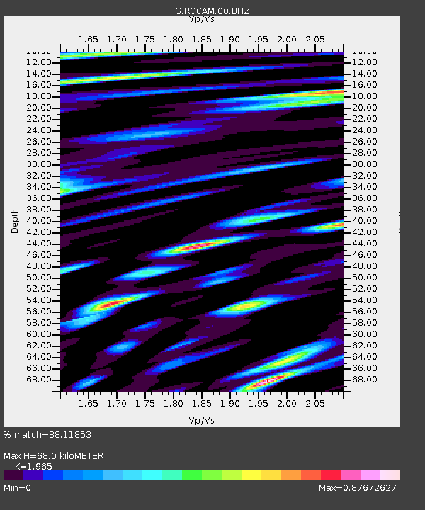
| Estimated Moho Depth: |
68.0 km |
| Estimated Crust Vp/Vs: |
1.97 |
| Assumed Crust Vp: |
4.802 km/s |
| Estimated Crust Vs: |
2.444 km/s |
| Estimated Crust Poisson's Ratio: |
0.33 |
|
| Radial Match: |
88.11853 % |
| Radial Bump: |
400 |
| Transverse Match: |
88.59764 % |
| Transverse Bump: |
400 |
| SOD ConfigId: |
29823551 |
| Insert Time: |
2023-01-23 17:57:19.484 +0000 |
| GWidth: |
2.5 |
| Max Bumps: |
400 |
| Tol: |
0.001 |
|

Signal To Noise
| Channel | StoN | STA | LTA |
| G:ROCAM:00:BHZ:20230109T17:57:37.999975Z | 9.007467 | 1.0787471E-5 | 1.1976141E-6 |
| G:ROCAM:00:BHN:20230109T17:57:37.999975Z | 1.2059568 | 1.1875566E-6 | 9.847421E-7 |
| G:ROCAM:00:BHE:20230109T17:57:37.999975Z | 3.4936378 | 4.50581E-6 | 1.2897187E-6 |
| Arrivals |
| Ps | 14 SECOND |
| PpPs | 41 SECOND |
| PsPs/PpSs | 55 SECOND |


