You are here: Home > Network List > GE - GEOFON Stations List
> Station EIL GEOFON Station Eilat, Israel > Earthquake Result Viewer
EIL GEOFON Station Eilat, Israel - Earthquake Result Viewer
| Earthquake location: |
Tanimbar Islands Reg., Indonesia |
| Earthquake latitude/longitude: |
-7.1/130.0 |
| Earthquake time(UTC): |
2023/01/09 (009) 17:47:34 GMT |
| Earthquake Depth: |
95 km |
| Earthquake Magnitude: |
7.6 mww |
| Earthquake Catalog/Contributor: |
NEIC PDE/us |
|
| Network: |
GE GEOFON |
| Station: |
EIL GEOFON Station Eilat, Israel |
| Lat/Lon: |
29.67 N/34.95 E |
| Elevation: |
210 m |
|
| Distance: |
97.9 deg |
| Az: |
298.939 deg |
| Baz: |
93.663 deg |
| Ray Param: |
0.040004376 |
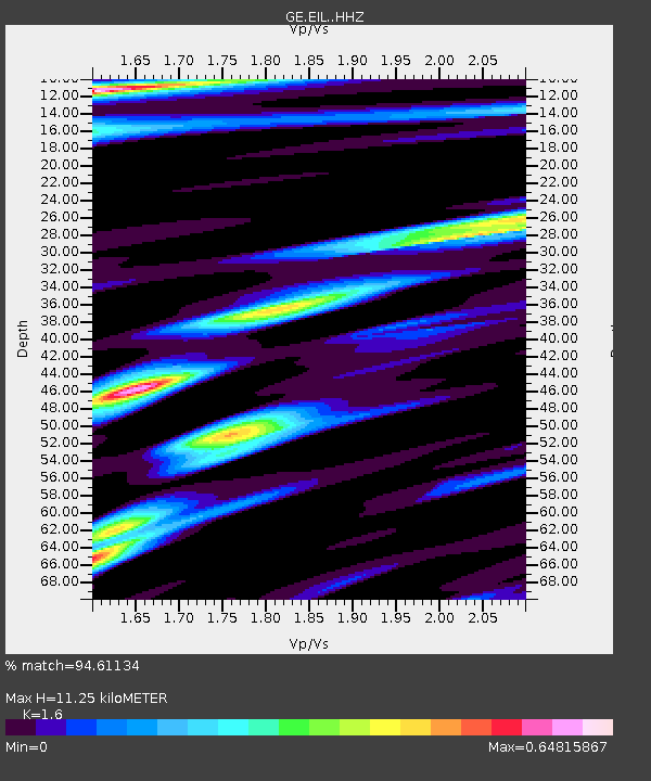
| Estimated Moho Depth: |
11.25 km |
| Estimated Crust Vp/Vs: |
1.60 |
| Assumed Crust Vp: |
6.472 km/s |
| Estimated Crust Vs: |
4.045 km/s |
| Estimated Crust Poisson's Ratio: |
0.18 |
|
| Radial Match: |
94.61134 % |
| Radial Bump: |
400 |
| Transverse Match: |
81.789925 % |
| Transverse Bump: |
400 |
| SOD ConfigId: |
29823551 |
| Insert Time: |
2023-01-23 17:57:22.866 +0000 |
| GWidth: |
2.5 |
| Max Bumps: |
400 |
| Tol: |
0.001 |
|

Signal To Noise
| Channel | StoN | STA | LTA |
| GE:EIL: :HHZ:20230109T18:00:27.75797Z | 7.625535 | 1.5610466E-6 | 2.0471306E-7 |
| GE:EIL: :HHN:20230109T18:00:27.75797Z | 1.968587 | 1.2084557E-7 | 6.138696E-8 |
| GE:EIL: :HHE:20230109T18:00:27.75797Z | 6.5360417 | 5.1763E-7 | 7.919625E-8 |
| Arrivals |
| Ps | 1.1 SECOND |
| PpPs | 4.4 SECOND |
| PsPs/PpSs | 5.5 SECOND |


