You are here: Home > Network List > GO - National Seismic Network of Georgia Stations List
> Station KHRT Khreiti, Georgia > Earthquake Result Viewer
KHRT Khreiti, Georgia - Earthquake Result Viewer
| Earthquake location: |
Tanimbar Islands Reg., Indonesia |
| Earthquake latitude/longitude: |
-7.1/130.0 |
| Earthquake time(UTC): |
2023/01/09 (009) 17:47:34 GMT |
| Earthquake Depth: |
95 km |
| Earthquake Magnitude: |
7.6 mww |
| Earthquake Catalog/Contributor: |
NEIC PDE/us |
|
| Network: |
GO National Seismic Network of Georgia |
| Station: |
KHRT Khreiti, Georgia |
| Lat/Lon: |
42.35 N/43.22 E |
| Elevation: |
1164 m |
|
| Distance: |
92.4 deg |
| Az: |
312.203 deg |
| Baz: |
97.348 deg |
| Ray Param: |
0.041424733 |
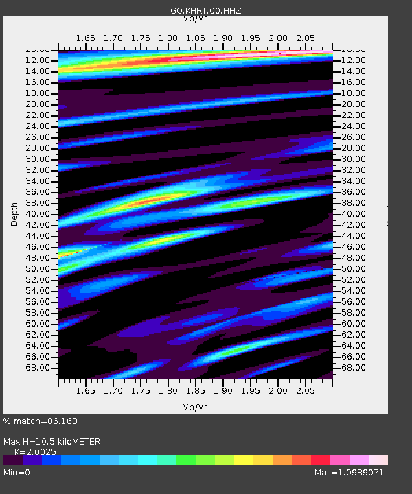
| Estimated Moho Depth: |
10.5 km |
| Estimated Crust Vp/Vs: |
2.00 |
| Assumed Crust Vp: |
6.247 km/s |
| Estimated Crust Vs: |
3.119 km/s |
| Estimated Crust Poisson's Ratio: |
0.33 |
|
| Radial Match: |
86.163 % |
| Radial Bump: |
400 |
| Transverse Match: |
74.57031 % |
| Transverse Bump: |
400 |
| SOD ConfigId: |
29823551 |
| Insert Time: |
2023-01-23 17:57:38.118 +0000 |
| GWidth: |
2.5 |
| Max Bumps: |
400 |
| Tol: |
0.001 |
|

Signal To Noise
| Channel | StoN | STA | LTA |
| GO:KHRT:00:HHZ:20230109T18:00:02.889989Z | 11.420522 | 3.3709584E-6 | 2.9516679E-7 |
| GO:KHRT:00:HHN:20230109T18:00:02.889989Z | 2.4140272 | 1.2224888E-6 | 5.064105E-7 |
| GO:KHRT:00:HHE:20230109T18:00:02.889989Z | 9.490602 | 1.1103602E-6 | 1.1699577E-7 |
| Arrivals |
| Ps | 1.7 SECOND |
| PpPs | 5.0 SECOND |
| PsPs/PpSs | 6.7 SECOND |


