You are here: Home > Network List > GO - National Seismic Network of Georgia Stations List
> Station KHAR Georgia, KHAR > Earthquake Result Viewer
KHAR Georgia, KHAR - Earthquake Result Viewer
| Earthquake location: |
Tanimbar Islands Reg., Indonesia |
| Earthquake latitude/longitude: |
-7.1/130.0 |
| Earthquake time(UTC): |
2023/01/09 (009) 17:47:34 GMT |
| Earthquake Depth: |
95 km |
| Earthquake Magnitude: |
7.6 mww |
| Earthquake Catalog/Contributor: |
NEIC PDE/us |
|
| Network: |
GO National Seismic Network of Georgia |
| Station: |
KHAR Georgia, KHAR |
| Lat/Lon: |
42.02 N/43.14 E |
| Elevation: |
680 m |
|
| Distance: |
92.4 deg |
| Az: |
311.863 deg |
| Baz: |
97.31 deg |
| Ray Param: |
0.041422103 |
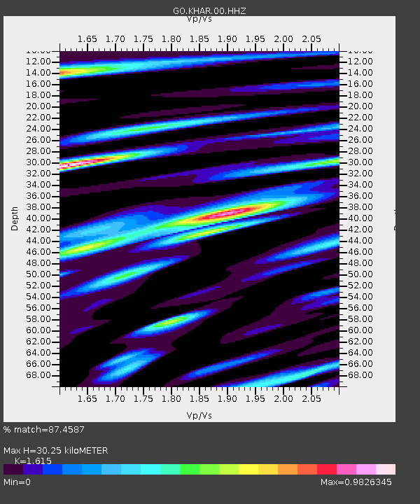
| Estimated Moho Depth: |
30.25 km |
| Estimated Crust Vp/Vs: |
1.62 |
| Assumed Crust Vp: |
6.247 km/s |
| Estimated Crust Vs: |
3.868 km/s |
| Estimated Crust Poisson's Ratio: |
0.19 |
|
| Radial Match: |
87.4587 % |
| Radial Bump: |
400 |
| Transverse Match: |
78.42784 % |
| Transverse Bump: |
400 |
| SOD ConfigId: |
29823551 |
| Insert Time: |
2023-01-23 17:57:38.332 +0000 |
| GWidth: |
2.5 |
| Max Bumps: |
400 |
| Tol: |
0.001 |
|

Signal To Noise
| Channel | StoN | STA | LTA |
| GO:KHAR:00:HHZ:20230109T18:00:02.959997Z | 12.269286 | 3.965966E-6 | 3.2324337E-7 |
| GO:KHAR:00:HHN:20230109T18:00:02.959997Z | 3.8800268 | 4.018214E-7 | 1.03561504E-7 |
| GO:KHAR:00:HHE:20230109T18:00:02.959997Z | 4.1547995 | 1.1120025E-6 | 2.676429E-7 |
| Arrivals |
| Ps | 3.0 SECOND |
| PpPs | 12 SECOND |
| PsPs/PpSs | 15 SECOND |


