You are here: Home > Network List > GO - National Seismic Network of Georgia Stations List
> Station TRLT Trialeti, Georgia > Earthquake Result Viewer
TRLT Trialeti, Georgia - Earthquake Result Viewer
| Earthquake location: |
Tanimbar Islands Reg., Indonesia |
| Earthquake latitude/longitude: |
-7.1/130.0 |
| Earthquake time(UTC): |
2023/01/09 (009) 17:47:34 GMT |
| Earthquake Depth: |
95 km |
| Earthquake Magnitude: |
7.6 mww |
| Earthquake Catalog/Contributor: |
NEIC PDE/us |
|
| Network: |
GO National Seismic Network of Georgia |
| Station: |
TRLT Trialeti, Georgia |
| Lat/Lon: |
41.57 N/44.15 E |
| Elevation: |
1668 m |
|
| Distance: |
91.6 deg |
| Az: |
311.521 deg |
| Baz: |
97.995 deg |
| Ray Param: |
0.041553766 |
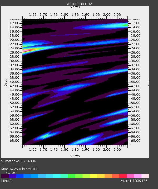
| Estimated Moho Depth: |
25.0 km |
| Estimated Crust Vp/Vs: |
1.60 |
| Assumed Crust Vp: |
6.291 km/s |
| Estimated Crust Vs: |
3.932 km/s |
| Estimated Crust Poisson's Ratio: |
0.18 |
|
| Radial Match: |
91.254036 % |
| Radial Bump: |
400 |
| Transverse Match: |
85.68728 % |
| Transverse Bump: |
400 |
| SOD ConfigId: |
29823551 |
| Insert Time: |
2023-01-23 17:57:46.897 +0000 |
| GWidth: |
2.5 |
| Max Bumps: |
400 |
| Tol: |
0.001 |
|

Signal To Noise
| Channel | StoN | STA | LTA |
| GO:TRLT:00:HHZ:20230109T17:59:59.230016Z | 12.205646 | 4.0330683E-6 | 3.3042647E-7 |
| GO:TRLT:00:HHN:20230109T17:59:59.230016Z | 26.17238 | 1.2284027E-6 | 4.6935078E-8 |
| GO:TRLT:00:HHE:20230109T17:59:59.230016Z | 9.779268 | 1.7554377E-6 | 1.7950603E-7 |
| Arrivals |
| Ps | 2.4 SECOND |
| PpPs | 10 SECOND |
| PsPs/PpSs | 13 SECOND |


