You are here: Home > Network List > NK - Nepal Kathmandu (NK) Stations List
> Station KKN Kakani, Nepal > Earthquake Result Viewer
KKN Kakani, Nepal - Earthquake Result Viewer
| Earthquake location: |
Tanimbar Islands Reg., Indonesia |
| Earthquake latitude/longitude: |
-7.1/130.0 |
| Earthquake time(UTC): |
2023/01/09 (009) 17:47:34 GMT |
| Earthquake Depth: |
95 km |
| Earthquake Magnitude: |
7.6 mww |
| Earthquake Catalog/Contributor: |
NEIC PDE/us |
|
| Network: |
NK Nepal Kathmandu (NK) |
| Station: |
KKN Kakani, Nepal |
| Lat/Lon: |
27.80 N/85.28 E |
| Elevation: |
2042 m |
|
| Distance: |
55.4 deg |
| Az: |
310.752 deg |
| Baz: |
121.93 deg |
| Ray Param: |
0.06452682 |
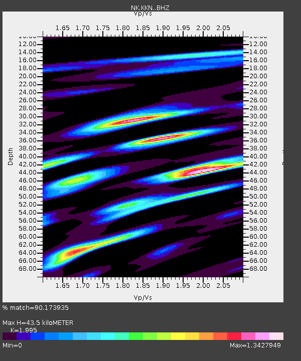
| Estimated Moho Depth: |
43.5 km |
| Estimated Crust Vp/Vs: |
2.00 |
| Assumed Crust Vp: |
6.142 km/s |
| Estimated Crust Vs: |
3.079 km/s |
| Estimated Crust Poisson's Ratio: |
0.33 |
|
| Radial Match: |
90.173935 % |
| Radial Bump: |
400 |
| Transverse Match: |
85.24597 % |
| Transverse Bump: |
400 |
| SOD ConfigId: |
29823551 |
| Insert Time: |
2023-01-23 18:00:20.923 +0000 |
| GWidth: |
2.5 |
| Max Bumps: |
400 |
| Tol: |
0.001 |
|

Signal To Noise
| Channel | StoN | STA | LTA |
| NK:KKN: :BHZ:20230109T17:56:28.280004Z | 11.486863 | 7.95469E-6 | 6.925032E-7 |
| NK:KKN: :BHN:20230109T17:56:28.280004Z | 10.419686 | 3.197322E-6 | 3.0685396E-7 |
| NK:KKN: :BHE:20230109T17:56:28.280004Z | 10.962835 | 4.240634E-6 | 3.8681912E-7 |
| Arrivals |
| Ps | 7.3 SECOND |
| PpPs | 20 SECOND |
| PsPs/PpSs | 28 SECOND |


