You are here: Home > Network List > QZ - Seismic network of the Seismological Experience and Methodology Expedition CS ME Stations List
> Station BRZS Bereznyaki Kazakhstan (SNECCA) > Earthquake Result Viewer
BRZS Bereznyaki Kazakhstan (SNECCA) - Earthquake Result Viewer
| Earthquake location: |
Tanimbar Islands Reg., Indonesia |
| Earthquake latitude/longitude: |
-7.1/130.0 |
| Earthquake time(UTC): |
2023/01/09 (009) 17:47:34 GMT |
| Earthquake Depth: |
95 km |
| Earthquake Magnitude: |
7.6 mww |
| Earthquake Catalog/Contributor: |
NEIC PDE/us |
|
| Network: |
QZ Seismic network of the Seismological Experience and Methodology Expedition CS ME |
| Station: |
BRZS Bereznyaki Kazakhstan (SNECCA) |
| Lat/Lon: |
49.98 N/72.68 E |
| Elevation: |
470 m |
|
| Distance: |
75.4 deg |
| Az: |
325.823 deg |
| Baz: |
120.276 deg |
| Ray Param: |
0.051476296 |
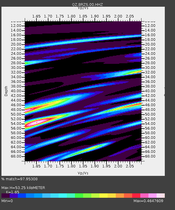
| Estimated Moho Depth: |
53.25 km |
| Estimated Crust Vp/Vs: |
1.65 |
| Assumed Crust Vp: |
6.571 km/s |
| Estimated Crust Vs: |
3.982 km/s |
| Estimated Crust Poisson's Ratio: |
0.21 |
|
| Radial Match: |
97.95308 % |
| Radial Bump: |
274 |
| Transverse Match: |
86.80046 % |
| Transverse Bump: |
400 |
| SOD ConfigId: |
29823551 |
| Insert Time: |
2023-01-23 18:00:40.956 +0000 |
| GWidth: |
2.5 |
| Max Bumps: |
400 |
| Tol: |
0.001 |
|

Signal To Noise
| Channel | StoN | STA | LTA |
| QZ:BRZS:00:HHZ:20230109T17:58:36.720006Z | 15.206066 | 7.922341E-6 | 5.2099875E-7 |
| QZ:BRZS:00:HHN:20230109T17:58:36.720006Z | 10.791644 | 1.155201E-6 | 1.0704587E-7 |
| QZ:BRZS:00:HHE:20230109T17:58:36.720006Z | 9.978352 | 2.7323179E-6 | 2.7382458E-7 |
| Arrivals |
| Ps | 5.5 SECOND |
| PpPs | 21 SECOND |
| PsPs/PpSs | 26 SECOND |


