You are here: Home > Network List > QZ - Seismic network of the Seismological Experience and Methodology Expedition CS ME Stations List
> Station SHLS Shalkode Kazakhstan (SNECCA) > Earthquake Result Viewer
SHLS Shalkode Kazakhstan (SNECCA) - Earthquake Result Viewer
| Earthquake location: |
Tanimbar Islands Reg., Indonesia |
| Earthquake latitude/longitude: |
-7.1/130.0 |
| Earthquake time(UTC): |
2023/01/09 (009) 17:47:34 GMT |
| Earthquake Depth: |
95 km |
| Earthquake Magnitude: |
7.6 mww |
| Earthquake Catalog/Contributor: |
NEIC PDE/us |
|
| Network: |
QZ Seismic network of the Seismological Experience and Methodology Expedition CS ME |
| Station: |
SHLS Shalkode Kazakhstan (SNECCA) |
| Lat/Lon: |
43.16 N/79.89 E |
| Elevation: |
2061 m |
|
| Distance: |
67.6 deg |
| Az: |
322.567 deg |
| Baz: |
124.469 deg |
| Ray Param: |
0.05664529 |
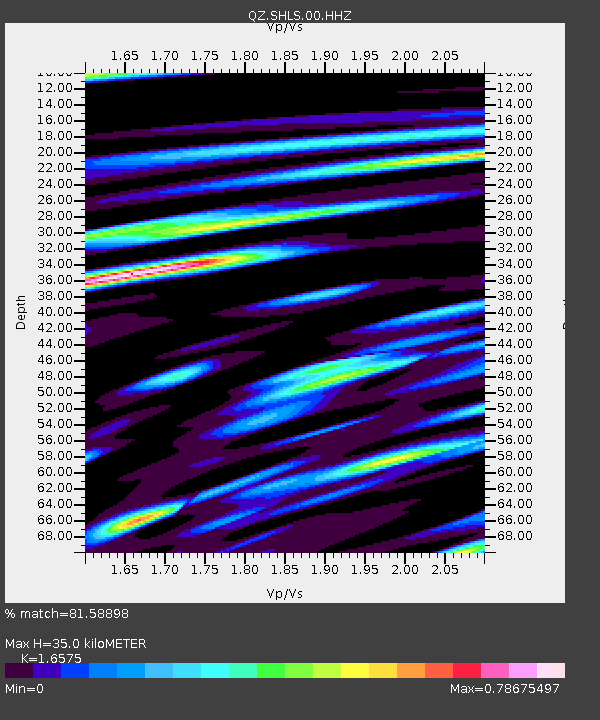
| Estimated Moho Depth: |
35.0 km |
| Estimated Crust Vp/Vs: |
1.66 |
| Assumed Crust Vp: |
6.306 km/s |
| Estimated Crust Vs: |
3.805 km/s |
| Estimated Crust Poisson's Ratio: |
0.21 |
|
| Radial Match: |
81.58898 % |
| Radial Bump: |
400 |
| Transverse Match: |
90.454254 % |
| Transverse Bump: |
400 |
| SOD ConfigId: |
29823551 |
| Insert Time: |
2023-01-23 18:00:48.199 +0000 |
| GWidth: |
2.5 |
| Max Bumps: |
400 |
| Tol: |
0.001 |
|

Signal To Noise
| Channel | StoN | STA | LTA |
| QZ:SHLS:00:HHZ:20230109T17:57:49.699987Z | 15.079851 | 7.449724E-6 | 4.9401837E-7 |
| QZ:SHLS:00:HHN:20230109T17:57:49.699987Z | 8.927449 | 1.8282288E-6 | 2.0478737E-7 |
| QZ:SHLS:00:HHE:20230109T17:57:49.699987Z | 12.51418 | 2.19698E-6 | 1.7555924E-7 |
| Arrivals |
| Ps | 3.8 SECOND |
| PpPs | 14 SECOND |
| PsPs/PpSs | 18 SECOND |


