You are here: Home > Network List > S1 - Australian Seismometers in Schools Stations List
> Station AULHS Lilydale High School > Earthquake Result Viewer
AULHS Lilydale High School - Earthquake Result Viewer
| Earthquake location: |
Tanimbar Islands Reg., Indonesia |
| Earthquake latitude/longitude: |
-7.1/130.0 |
| Earthquake time(UTC): |
2023/01/09 (009) 17:47:34 GMT |
| Earthquake Depth: |
95 km |
| Earthquake Magnitude: |
7.6 mww |
| Earthquake Catalog/Contributor: |
NEIC PDE/us |
|
| Network: |
S1 Australian Seismometers in Schools |
| Station: |
AULHS Lilydale High School |
| Lat/Lon: |
41.25 S/147.21 E |
| Elevation: |
173 m |
|
| Distance: |
37.3 deg |
| Az: |
158.444 deg |
| Baz: |
331.079 deg |
| Ray Param: |
0.07590346 |
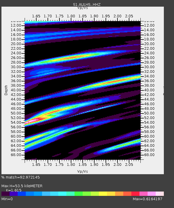
| Estimated Moho Depth: |
53.5 km |
| Estimated Crust Vp/Vs: |
1.62 |
| Assumed Crust Vp: |
6.39 km/s |
| Estimated Crust Vs: |
3.957 km/s |
| Estimated Crust Poisson's Ratio: |
0.19 |
|
| Radial Match: |
92.972145 % |
| Radial Bump: |
300 |
| Transverse Match: |
81.521286 % |
| Transverse Bump: |
400 |
| SOD ConfigId: |
29823551 |
| Insert Time: |
2023-01-23 18:01:04.638 +0000 |
| GWidth: |
2.5 |
| Max Bumps: |
400 |
| Tol: |
0.001 |
|

Signal To Noise
| Channel | StoN | STA | LTA |
| S1:AULHS: :HHZ:20230109T17:54:06.840001Z | 6.7339416 | 5.895057E-6 | 8.754244E-7 |
| S1:AULHS: :HHN:20230109T17:54:06.840001Z | 4.4384565 | 3.6800848E-6 | 8.291361E-7 |
| S1:AULHS: :HHE:20230109T17:54:06.840001Z | 1.703593 | 1.0828162E-6 | 6.356073E-7 |
| Arrivals |
| Ps | 5.6 SECOND |
| PpPs | 20 SECOND |
| PsPs/PpSs | 26 SECOND |


