You are here: Home > Network List > TM - Thai Seismic Monitoring Network Stations List
> Station SKLT Mueang, Songkhla > Earthquake Result Viewer
SKLT Mueang, Songkhla - Earthquake Result Viewer
| Earthquake location: |
Tanimbar Islands Reg., Indonesia |
| Earthquake latitude/longitude: |
-7.1/130.0 |
| Earthquake time(UTC): |
2023/01/09 (009) 17:47:34 GMT |
| Earthquake Depth: |
95 km |
| Earthquake Magnitude: |
7.6 mww |
| Earthquake Catalog/Contributor: |
NEIC PDE/us |
|
| Network: |
TM Thai Seismic Monitoring Network |
| Station: |
SKLT Mueang, Songkhla |
| Lat/Lon: |
7.18 N/100.62 E |
| Elevation: |
11 m |
|
| Distance: |
32.6 deg |
| Az: |
295.169 deg |
| Baz: |
115.145 deg |
| Ray Param: |
0.07833272 |
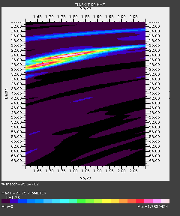
| Estimated Moho Depth: |
23.75 km |
| Estimated Crust Vp/Vs: |
1.78 |
| Assumed Crust Vp: |
6.468 km/s |
| Estimated Crust Vs: |
3.634 km/s |
| Estimated Crust Poisson's Ratio: |
0.27 |
|
| Radial Match: |
95.54782 % |
| Radial Bump: |
210 |
| Transverse Match: |
56.533558 % |
| Transverse Bump: |
400 |
| SOD ConfigId: |
29823551 |
| Insert Time: |
2023-01-23 18:01:40.036 +0000 |
| GWidth: |
2.5 |
| Max Bumps: |
400 |
| Tol: |
0.001 |
|

Signal To Noise
| Channel | StoN | STA | LTA |
| TM:SKLT:00:HHZ:20230109T17:53:26.424993Z | 11.376238 | 7.891216E-6 | 6.936578E-7 |
| TM:SKLT:00:HHN:20230109T17:53:26.424993Z | 9.693586 | 2.1654294E-6 | 2.2338784E-7 |
| TM:SKLT:00:HHE:20230109T17:53:26.424993Z | 9.950619 | 5.0956583E-6 | 5.120946E-7 |
| Arrivals |
| Ps | 3.1 SECOND |
| PpPs | 9.4 SECOND |
| PsPs/PpSs | 13 SECOND |


