You are here: Home > Network List > GM - US Geological Survey Networks Stations List
> Station IWM01 Jericho 2M Well Monitoring Station > Earthquake Result Viewer
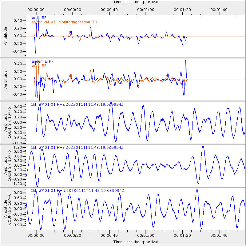
IWM01 Jericho 2M Well Monitoring Station - Earthquake Result Viewer
*The percent match for this event was below the threshold and hence no stack was calculated.
| Earthquake location: |
Tonga Islands Region |
| Earthquake latitude/longitude: |
-23.2/-175.3 |
| Earthquake time(UTC): |
2023/01/11 (011) 11:30:27 GMT |
| Earthquake Depth: |
10 km |
| Earthquake Magnitude: |
5.6 Mww |
| Earthquake Catalog/Contributor: |
NEIC PDE/us |
|
| Network: |
GM US Geological Survey Networks |
| Station: |
IWM01 Jericho 2M Well Monitoring Station |
| Lat/Lon: |
36.73 N/96.53 W |
| Elevation: |
328 m |
|
| Distance: |
95.2 deg |
| Az: |
52.311 deg |
| Baz: |
244.982 deg |
| Ray Param: |
$rayparam |
*The percent match for this event was below the threshold and hence was not used in the summary stack. |
|
| Radial Match: |
82.60226 % |
| Radial Bump: |
400 |
| Transverse Match: |
70.96851 % |
| Transverse Bump: |
400 |
| SOD ConfigId: |
29823551 |
| Insert Time: |
2023-01-25 11:39:39.406 +0000 |
| GWidth: |
2.5 |
| Max Bumps: |
400 |
| Tol: |
0.001 |
|
Signal To Noise
| Channel | StoN | STA | LTA |
| GM:IWM01:01:HHZ:20230111T11:43:19.639994Z | 2.2170446 | 8.6327975E-7 | 3.893831E-7 |
| GM:IWM01:01:HHN:20230111T11:43:19.639994Z | 2.2159522 | 7.525645E-7 | 3.3961226E-7 |
| GM:IWM01:01:HHE:20230111T11:43:19.639994Z | 0.8127878 | 1.9824546E-7 | 2.4390803E-7 |
| Arrivals |
| Ps | |
| PpPs | |
| PsPs/PpSs | |


