You are here: Home > Network List > US - United States National Seismic Network Stations List
> Station EGMT Eagleton, Montana, USA > Earthquake Result Viewer
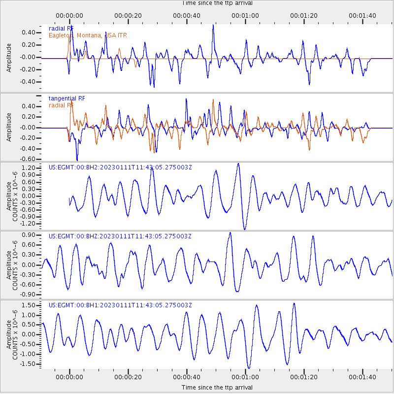
EGMT Eagleton, Montana, USA - Earthquake Result Viewer
*The percent match for this event was below the threshold and hence no stack was calculated.
| Earthquake location: |
Tonga Islands Region |
| Earthquake latitude/longitude: |
-23.2/-175.3 |
| Earthquake time(UTC): |
2023/01/11 (011) 11:30:27 GMT |
| Earthquake Depth: |
10 km |
| Earthquake Magnitude: |
5.6 Mww |
| Earthquake Catalog/Contributor: |
NEIC PDE/us |
|
| Network: |
US United States National Seismic Network |
| Station: |
EGMT Eagleton, Montana, USA |
| Lat/Lon: |
48.02 N/109.75 W |
| Elevation: |
1055 m |
|
| Distance: |
92.0 deg |
| Az: |
37.709 deg |
| Baz: |
236.956 deg |
| Ray Param: |
$rayparam |
*The percent match for this event was below the threshold and hence was not used in the summary stack. |
|
| Radial Match: |
40.227833 % |
| Radial Bump: |
400 |
| Transverse Match: |
45.36736 % |
| Transverse Bump: |
400 |
| SOD ConfigId: |
29823551 |
| Insert Time: |
2023-01-25 11:47:42.034 +0000 |
| GWidth: |
2.5 |
| Max Bumps: |
400 |
| Tol: |
0.001 |
|
Signal To Noise
| Channel | StoN | STA | LTA |
| US:EGMT:00:BHZ:20230111T11:43:05.275003Z | 1.8890877 | 4.961445E-7 | 2.626371E-7 |
| US:EGMT:00:BH1:20230111T11:43:05.275003Z | 1.259939 | 5.922694E-7 | 4.7007782E-7 |
| US:EGMT:00:BH2:20230111T11:43:05.275003Z | 0.92546785 | 4.263379E-7 | 4.6067282E-7 |
| Arrivals |
| Ps | |
| PpPs | |
| PsPs/PpSs | |


