You are here: Home > Network List > TA - USArray Transportable Network (new EarthScope stations) Stations List
> Station C24A Savage, MT, USA > Earthquake Result Viewer
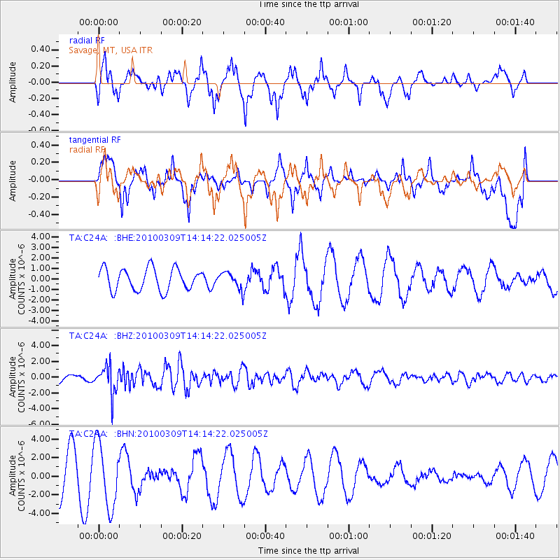
C24A Savage, MT, USA - Earthquake Result Viewer
*The percent match for this event was below the threshold and hence no stack was calculated.
| Earthquake location: |
Andreanof Islands, Aleutian Is. |
| Earthquake latitude/longitude: |
51.5/-173.5 |
| Earthquake time(UTC): |
2010/03/09 (068) 14:06:52 GMT |
| Earthquake Depth: |
35 km |
| Earthquake Magnitude: |
5.7 MB, 5.5 MS, 5.9 MW, 5.8 MW |
| Earthquake Catalog/Contributor: |
WHDF/NEIC |
|
| Network: |
TA USArray Transportable Network (new EarthScope stations) |
| Station: |
C24A Savage, MT, USA |
| Lat/Lon: |
47.53 N/104.43 W |
| Elevation: |
713 m |
|
| Distance: |
43.5 deg |
| Az: |
66.815 deg |
| Baz: |
301.994 deg |
| Ray Param: |
$rayparam |
*The percent match for this event was below the threshold and hence was not used in the summary stack. |
|
| Radial Match: |
52.400055 % |
| Radial Bump: |
364 |
| Transverse Match: |
32.17743 % |
| Transverse Bump: |
365 |
| SOD ConfigId: |
299721 |
| Insert Time: |
2010-04-26 20:57:12.071 +0000 |
| GWidth: |
2.5 |
| Max Bumps: |
400 |
| Tol: |
0.001 |
|
Signal To Noise
| Channel | StoN | STA | LTA |
| TA:C24A: :BHZ:20100309T14:14:22.025005Z | 4.4813895 | 1.8045846E-6 | 4.0268415E-7 |
| TA:C24A: :BHN:20100309T14:14:22.025005Z | 1.903449 | 3.5093747E-6 | 1.8436924E-6 |
| TA:C24A: :BHE:20100309T14:14:22.025005Z | 0.81537694 | 8.554067E-7 | 1.0490936E-6 |
| Arrivals |
| Ps | |
| PpPs | |
| PsPs/PpSs | |


