You are here: Home > Network List > TA - USArray Transportable Network (new EarthScope stations) Stations List
> Station BRSD Miller, SD, USA > Earthquake Result Viewer
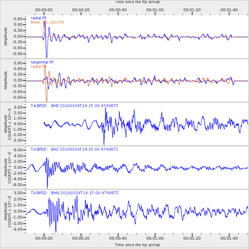
BRSD Miller, SD, USA - Earthquake Result Viewer
*The percent match for this event was below the threshold and hence no stack was calculated.
| Earthquake location: |
Andreanof Islands, Aleutian Is. |
| Earthquake latitude/longitude: |
51.5/-173.5 |
| Earthquake time(UTC): |
2010/03/09 (068) 14:06:52 GMT |
| Earthquake Depth: |
35 km |
| Earthquake Magnitude: |
5.7 MB, 5.5 MS, 5.9 MW, 5.8 MW |
| Earthquake Catalog/Contributor: |
WHDF/NEIC |
|
| Network: |
TA USArray Transportable Network (new EarthScope stations) |
| Station: |
BRSD Miller, SD, USA |
| Lat/Lon: |
44.44 N/98.96 W |
| Elevation: |
519 m |
|
| Distance: |
48.4 deg |
| Az: |
67.388 deg |
| Baz: |
306.316 deg |
| Ray Param: |
$rayparam |
*The percent match for this event was below the threshold and hence was not used in the summary stack. |
|
| Radial Match: |
74.58927 % |
| Radial Bump: |
400 |
| Transverse Match: |
60.163406 % |
| Transverse Bump: |
400 |
| SOD ConfigId: |
299721 |
| Insert Time: |
2010-04-26 20:57:39.329 +0000 |
| GWidth: |
2.5 |
| Max Bumps: |
400 |
| Tol: |
0.001 |
|
Signal To Noise
| Channel | StoN | STA | LTA |
| TA:BRSD: :BHZ:20100309T14:15:00.474987Z | 5.884891 | 2.2028091E-6 | 3.7431604E-7 |
| TA:BRSD: :BHN:20100309T14:15:00.474987Z | 2.5531838 | 1.0449847E-6 | 4.0928694E-7 |
| TA:BRSD: :BHE:20100309T14:15:00.474987Z | 3.3229156 | 1.1966661E-6 | 3.6012534E-7 |
| Arrivals |
| Ps | |
| PpPs | |
| PsPs/PpSs | |


