You are here: Home > Network List > TA - USArray Transportable Network (new EarthScope stations) Stations List
> Station M25A Palm-Egli Farm, Albin, WY, USA > Earthquake Result Viewer
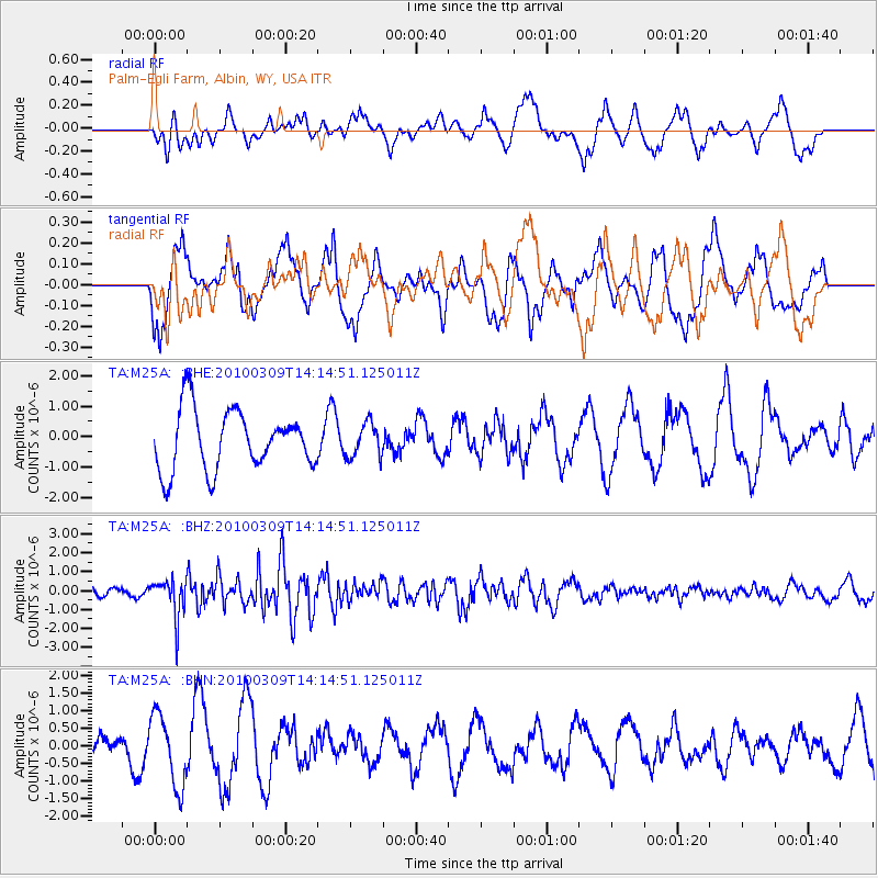
M25A Palm-Egli Farm, Albin, WY, USA - Earthquake Result Viewer
*The percent match for this event was below the threshold and hence no stack was calculated.
| Earthquake location: |
Andreanof Islands, Aleutian Is. |
| Earthquake latitude/longitude: |
51.5/-173.5 |
| Earthquake time(UTC): |
2010/03/09 (068) 14:06:52 GMT |
| Earthquake Depth: |
35 km |
| Earthquake Magnitude: |
5.7 MB, 5.5 MS, 5.9 MW, 5.8 MW |
| Earthquake Catalog/Contributor: |
WHDF/NEIC |
|
| Network: |
TA USArray Transportable Network (new EarthScope stations) |
| Station: |
M25A Palm-Egli Farm, Albin, WY, USA |
| Lat/Lon: |
41.43 N/104.06 W |
| Elevation: |
1636 m |
|
| Distance: |
47.2 deg |
| Az: |
73.66 deg |
| Baz: |
307.067 deg |
| Ray Param: |
$rayparam |
*The percent match for this event was below the threshold and hence was not used in the summary stack. |
|
| Radial Match: |
45.30131 % |
| Radial Bump: |
400 |
| Transverse Match: |
58.586617 % |
| Transverse Bump: |
400 |
| SOD ConfigId: |
299721 |
| Insert Time: |
2010-04-26 20:58:32.045 +0000 |
| GWidth: |
2.5 |
| Max Bumps: |
400 |
| Tol: |
0.001 |
|
Signal To Noise
| Channel | StoN | STA | LTA |
| TA:M25A: :BHZ:20100309T14:14:51.125011Z | 3.9918268 | 1.0199022E-6 | 2.554976E-7 |
| TA:M25A: :BHN:20100309T14:14:51.125011Z | 2.2968025 | 1.0103912E-6 | 4.3991207E-7 |
| TA:M25A: :BHE:20100309T14:14:51.125011Z | 0.57345515 | 5.606745E-7 | 9.777128E-7 |
| Arrivals |
| Ps | |
| PpPs | |
| PsPs/PpSs | |


