You are here: Home > Network List > CI - Caltech Regional Seismic Network Stations List
> Station SWS Sam W. Stewart, Westmorland, CA, USA > Earthquake Result Viewer
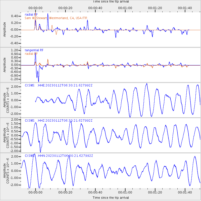
SWS Sam W. Stewart, Westmorland, CA, USA - Earthquake Result Viewer
*The percent match for this event was below the threshold and hence no stack was calculated.
| Earthquake location: |
Near Coast Of Central Chile |
| Earthquake latitude/longitude: |
-30.6/-71.2 |
| Earthquake time(UTC): |
2023/01/12 (012) 06:19:11 GMT |
| Earthquake Depth: |
57 km |
| Earthquake Magnitude: |
5.5 mww |
| Earthquake Catalog/Contributor: |
NEIC PDE/us |
|
| Network: |
CI Caltech Regional Seismic Network |
| Station: |
SWS Sam W. Stewart, Westmorland, CA, USA |
| Lat/Lon: |
32.94 N/115.80 W |
| Elevation: |
140 m |
|
| Distance: |
76.0 deg |
| Az: |
322.544 deg |
| Baz: |
141.438 deg |
| Ray Param: |
$rayparam |
*The percent match for this event was below the threshold and hence was not used in the summary stack. |
|
| Radial Match: |
51.87593 % |
| Radial Bump: |
276 |
| Transverse Match: |
81.0815 % |
| Transverse Bump: |
334 |
| SOD ConfigId: |
29823551 |
| Insert Time: |
2023-01-26 06:23:56.660 +0000 |
| GWidth: |
2.5 |
| Max Bumps: |
400 |
| Tol: |
0.001 |
|
Signal To Noise
| Channel | StoN | STA | LTA |
| CI:SWS: :HHZ:20230112T06:30:21.627992Z | 2.4170823 | 1.2551506E-6 | 5.1928333E-7 |
| CI:SWS: :HHN:20230112T06:30:21.627992Z | 2.0497677 | 1.6965711E-6 | 8.2768946E-7 |
| CI:SWS: :HHE:20230112T06:30:21.627992Z | 3.7534168 | 1.1801093E-6 | 3.1440933E-7 |
| Arrivals |
| Ps | |
| PpPs | |
| PsPs/PpSs | |


