You are here: Home > Network List > IW - Intermountain West Stations List
> Station MOOW Moose Ponds, Wyoming, USA > Earthquake Result Viewer
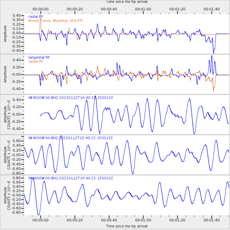
MOOW Moose Ponds, Wyoming, USA - Earthquake Result Viewer
*The percent match for this event was below the threshold and hence no stack was calculated.
| Earthquake location: |
South Of Fiji Islands |
| Earthquake latitude/longitude: |
-21.9/179.8 |
| Earthquake time(UTC): |
2023/01/12 (012) 16:28:51 GMT |
| Earthquake Depth: |
596 km |
| Earthquake Magnitude: |
5.5 Mww |
| Earthquake Catalog/Contributor: |
NEIC PDE/us |
|
| Network: |
IW Intermountain West |
| Station: |
MOOW Moose Ponds, Wyoming, USA |
| Lat/Lon: |
43.75 N/110.74 W |
| Elevation: |
2128 m |
|
| Distance: |
91.1 deg |
| Az: |
42.762 deg |
| Baz: |
240.462 deg |
| Ray Param: |
$rayparam |
*The percent match for this event was below the threshold and hence was not used in the summary stack. |
|
| Radial Match: |
50.063366 % |
| Radial Bump: |
400 |
| Transverse Match: |
77.845 % |
| Transverse Bump: |
400 |
| SOD ConfigId: |
29823551 |
| Insert Time: |
2023-01-26 16:39:23.665 +0000 |
| GWidth: |
2.5 |
| Max Bumps: |
400 |
| Tol: |
0.001 |
|
Signal To Noise
| Channel | StoN | STA | LTA |
| IW:MOOW:00:BHZ:20230112T16:40:22.150013Z | 1.3666264 | 3.0143025E-7 | 2.2056523E-7 |
| IW:MOOW:00:BH1:20230112T16:40:22.150013Z | 2.1391487 | 4.9093944E-7 | 2.2950226E-7 |
| IW:MOOW:00:BH2:20230112T16:40:22.150013Z | 2.6833036 | 3.6430995E-7 | 1.3576918E-7 |
| Arrivals |
| Ps | |
| PpPs | |
| PsPs/PpSs | |


