You are here: Home > Network List > US - United States National Seismic Network Stations List
> Station DGMT Dagmar, Montana, USA > Earthquake Result Viewer
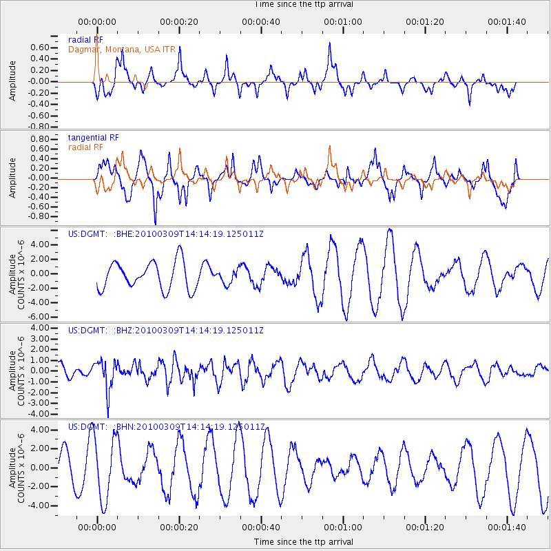
DGMT Dagmar, Montana, USA - Earthquake Result Viewer
*The percent match for this event was below the threshold and hence no stack was calculated.
| Earthquake location: |
Andreanof Islands, Aleutian Is. |
| Earthquake latitude/longitude: |
51.5/-173.5 |
| Earthquake time(UTC): |
2010/03/09 (068) 14:06:52 GMT |
| Earthquake Depth: |
35 km |
| Earthquake Magnitude: |
5.7 MB, 5.5 MS, 5.9 MW, 5.8 MW |
| Earthquake Catalog/Contributor: |
WHDF/NEIC |
|
| Network: |
US United States National Seismic Network |
| Station: |
DGMT Dagmar, Montana, USA |
| Lat/Lon: |
48.47 N/104.20 W |
| Elevation: |
0.0 m |
|
| Distance: |
43.2 deg |
| Az: |
65.53 deg |
| Baz: |
301.23 deg |
| Ray Param: |
$rayparam |
*The percent match for this event was below the threshold and hence was not used in the summary stack. |
|
| Radial Match: |
53.981438 % |
| Radial Bump: |
394 |
| Transverse Match: |
38.080326 % |
| Transverse Bump: |
328 |
| SOD ConfigId: |
299721 |
| Insert Time: |
2010-04-26 21:11:17.423 +0000 |
| GWidth: |
2.5 |
| Max Bumps: |
400 |
| Tol: |
0.001 |
|
Signal To Noise
| Channel | StoN | STA | LTA |
| US:DGMT: :BHZ:20100309T14:14:19.125011Z | 2.2136204 | 1.4046922E-6 | 6.345677E-7 |
| US:DGMT: :BHN:20100309T14:14:19.125011Z | 1.590504 | 3.30722E-6 | 2.0793534E-6 |
| US:DGMT: :BHE:20100309T14:14:19.125011Z | 0.5147383 | 9.705866E-7 | 1.8855924E-6 |
| Arrivals |
| Ps | |
| PpPs | |
| PsPs/PpSs | |


