You are here: Home > Network List > TA - USArray Transportable Network (new EarthScope stations) Stations List
> Station Y14A Wickenburg, AZ, USA > Earthquake Result Viewer
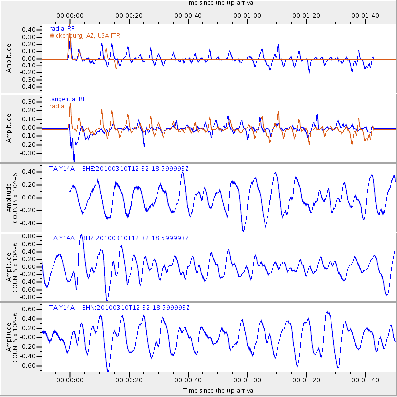
Y14A Wickenburg, AZ, USA - Earthquake Result Viewer
*The percent match for this event was below the threshold and hence no stack was calculated.
| Earthquake location: |
Off Coast Of Central Chile |
| Earthquake latitude/longitude: |
-33.6/-72.3 |
| Earthquake time(UTC): |
2010/03/10 (069) 12:20:58 GMT |
| Earthquake Depth: |
35 km |
| Earthquake Magnitude: |
5.5 MB, 5.5 MS |
| Earthquake Catalog/Contributor: |
WHDF/NEIC |
|
| Network: |
TA USArray Transportable Network (new EarthScope stations) |
| Station: |
Y14A Wickenburg, AZ, USA |
| Lat/Lon: |
33.94 N/113.00 W |
| Elevation: |
731 m |
|
| Distance: |
77.3 deg |
| Az: |
326.228 deg |
| Baz: |
146.061 deg |
| Ray Param: |
$rayparam |
*The percent match for this event was below the threshold and hence was not used in the summary stack. |
|
| Radial Match: |
57.66819 % |
| Radial Bump: |
400 |
| Transverse Match: |
33.89297 % |
| Transverse Bump: |
400 |
| SOD ConfigId: |
299721 |
| Insert Time: |
2010-04-26 21:17:14.217 +0000 |
| GWidth: |
2.5 |
| Max Bumps: |
400 |
| Tol: |
0.001 |
|
Signal To Noise
| Channel | StoN | STA | LTA |
| TA:Y14A: :BHZ:20100310T12:32:18.599993Z | 2.1371346 | 4.892773E-7 | 2.2894079E-7 |
| TA:Y14A: :BHN:20100310T12:32:18.599993Z | 0.78009564 | 1.8283565E-7 | 2.3437595E-7 |
| TA:Y14A: :BHE:20100310T12:32:18.599993Z | 0.8284826 | 1.4394263E-7 | 1.7374249E-7 |
| Arrivals |
| Ps | |
| PpPs | |
| PsPs/PpSs | |


