You are here: Home > Network List > TA - USArray Transportable Network (new EarthScope stations) Stations List
> Station Z14A Wintersburg, AZ, USA > Earthquake Result Viewer
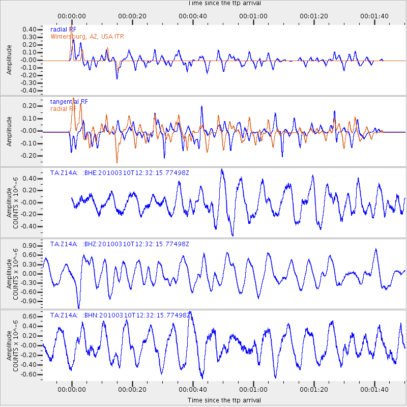
Z14A Wintersburg, AZ, USA - Earthquake Result Viewer
*The percent match for this event was below the threshold and hence no stack was calculated.
| Earthquake location: |
Off Coast Of Central Chile |
| Earthquake latitude/longitude: |
-33.6/-72.3 |
| Earthquake time(UTC): |
2010/03/10 (069) 12:20:58 GMT |
| Earthquake Depth: |
35 km |
| Earthquake Magnitude: |
5.5 MB, 5.5 MS |
| Earthquake Catalog/Contributor: |
WHDF/NEIC |
|
| Network: |
TA USArray Transportable Network (new EarthScope stations) |
| Station: |
Z14A Wintersburg, AZ, USA |
| Lat/Lon: |
33.36 N/112.95 W |
| Elevation: |
298 m |
|
| Distance: |
76.8 deg |
| Az: |
325.941 deg |
| Baz: |
146.029 deg |
| Ray Param: |
$rayparam |
*The percent match for this event was below the threshold and hence was not used in the summary stack. |
|
| Radial Match: |
64.14892 % |
| Radial Bump: |
400 |
| Transverse Match: |
53.815334 % |
| Transverse Bump: |
400 |
| SOD ConfigId: |
299721 |
| Insert Time: |
2010-04-26 21:17:15.295 +0000 |
| GWidth: |
2.5 |
| Max Bumps: |
400 |
| Tol: |
0.001 |
|
Signal To Noise
| Channel | StoN | STA | LTA |
| TA:Z14A: :BHZ:20100310T12:32:15.77498Z | 2.7854161 | 5.111348E-7 | 1.8350391E-7 |
| TA:Z14A: :BHN:20100310T12:32:15.77498Z | 2.313468 | 3.070155E-7 | 1.3270792E-7 |
| TA:Z14A: :BHE:20100310T12:32:15.77498Z | 1.0982947 | 1.1947698E-7 | 1.08784064E-7 |
| Arrivals |
| Ps | |
| PpPs | |
| PsPs/PpSs | |


