You are here: Home > Network List > GO - National Seismic Network of Georgia Stations List
> Station KHAR Georgia, KHAR > Earthquake Result Viewer
KHAR Georgia, KHAR - Earthquake Result Viewer
| Earthquake location: |
Northern Sumatra, Indonesia |
| Earthquake latitude/longitude: |
2.0/98.0 |
| Earthquake time(UTC): |
2023/01/15 (015) 22:29:58 GMT |
| Earthquake Depth: |
37 km |
| Earthquake Magnitude: |
6.2 Mww |
| Earthquake Catalog/Contributor: |
NEIC PDE/us |
|
| Network: |
GO National Seismic Network of Georgia |
| Station: |
KHAR Georgia, KHAR |
| Lat/Lon: |
42.02 N/43.14 E |
| Elevation: |
680 m |
|
| Distance: |
63.1 deg |
| Az: |
316.912 deg |
| Baz: |
113.628 deg |
| Ray Param: |
0.05970494 |
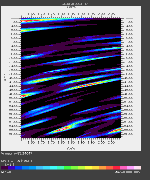
| Estimated Moho Depth: |
11.5 km |
| Estimated Crust Vp/Vs: |
1.60 |
| Assumed Crust Vp: |
6.247 km/s |
| Estimated Crust Vs: |
3.904 km/s |
| Estimated Crust Poisson's Ratio: |
0.18 |
|
| Radial Match: |
85.24047 % |
| Radial Bump: |
400 |
| Transverse Match: |
89.054375 % |
| Transverse Bump: |
400 |
| SOD ConfigId: |
29823551 |
| Insert Time: |
2023-01-29 22:36:43.033 +0000 |
| GWidth: |
2.5 |
| Max Bumps: |
400 |
| Tol: |
0.001 |
|

Signal To Noise
| Channel | StoN | STA | LTA |
| GO:KHAR:00:HHZ:20230115T22:39:52.249994Z | 24.850647 | 2.1222552E-6 | 8.5400394E-8 |
| GO:KHAR:00:HHN:20230115T22:39:52.249994Z | 2.6006544 | 3.1716263E-7 | 1.2195494E-7 |
| GO:KHAR:00:HHE:20230115T22:39:52.249994Z | 4.383213 | 7.820671E-7 | 1.7842325E-7 |
| Arrivals |
| Ps | 1.2 SECOND |
| PpPs | 4.6 SECOND |
| PsPs/PpSs | 5.7 SECOND |


