You are here: Home > Network List > CB - China National Seismic Network Stations List
> Station HEH Heihe,Heilongjiang Province > Earthquake Result Viewer
HEH Heihe,Heilongjiang Province - Earthquake Result Viewer
| Earthquake location: |
New Guinea, Papua New Guinea |
| Earthquake latitude/longitude: |
-6.5/143.3 |
| Earthquake time(UTC): |
2018/02/26 (057) 15:17:57 GMT |
| Earthquake Depth: |
5.2 km |
| Earthquake Magnitude: |
6.3 Mww |
| Earthquake Catalog/Contributor: |
NEIC PDE/us |
|
| Network: |
CB China National Seismic Network |
| Station: |
HEH Heihe,Heilongjiang Province |
| Lat/Lon: |
50.25 N/127.41 E |
| Elevation: |
165 m |
|
| Distance: |
58.2 deg |
| Az: |
348.09 deg |
| Baz: |
161.371 deg |
| Ray Param: |
0.063028194 |
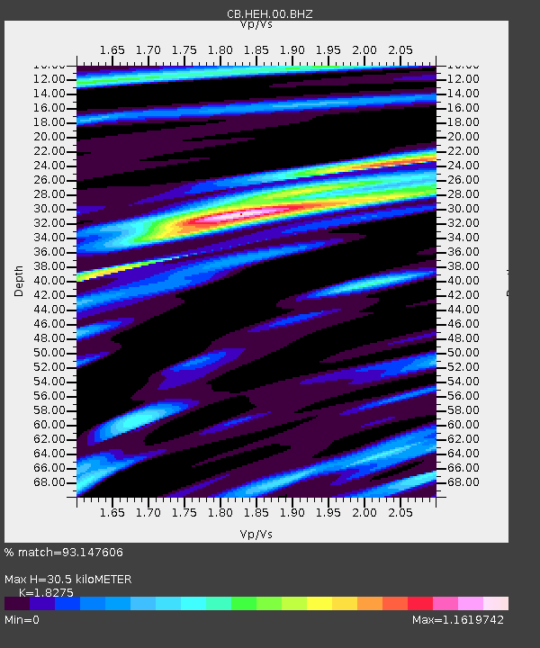
| Estimated Moho Depth: |
30.5 km |
| Estimated Crust Vp/Vs: |
1.83 |
| Assumed Crust Vp: |
6.419 km/s |
| Estimated Crust Vs: |
3.513 km/s |
| Estimated Crust Poisson's Ratio: |
0.29 |
|
| Radial Match: |
93.147606 % |
| Radial Bump: |
378 |
| Transverse Match: |
65.420746 % |
| Transverse Bump: |
400 |
| SOD ConfigId: |
2973751 |
| Insert Time: |
2018-10-09 08:44:01.479 +0000 |
| GWidth: |
2.5 |
| Max Bumps: |
400 |
| Tol: |
0.001 |
|
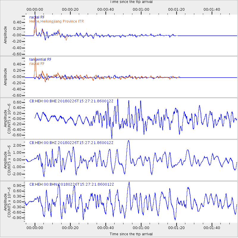
Signal To Noise
| Channel | StoN | STA | LTA |
| CB:HEH:00:BHZ:20180226T15:27:21.860012Z | 6.693279 | 6.1571393E-7 | 9.198989E-8 |
| CB:HEH:00:BHN:20180226T15:27:21.860012Z | 2.3440866 | 2.5467395E-7 | 1.0864529E-7 |
| CB:HEH:00:BHE:20180226T15:27:21.860012Z | 1.4182334 | 1.4624382E-7 | 1.03116896E-7 |
| Arrivals |
| Ps | 4.1 SECOND |
| PpPs | 13 SECOND |
| PsPs/PpSs | 17 SECOND |


