You are here: Home > Network List > TA - USArray Transportable Network (new EarthScope stations) Stations List
> Station L23A Garrett, WY, USA > Earthquake Result Viewer
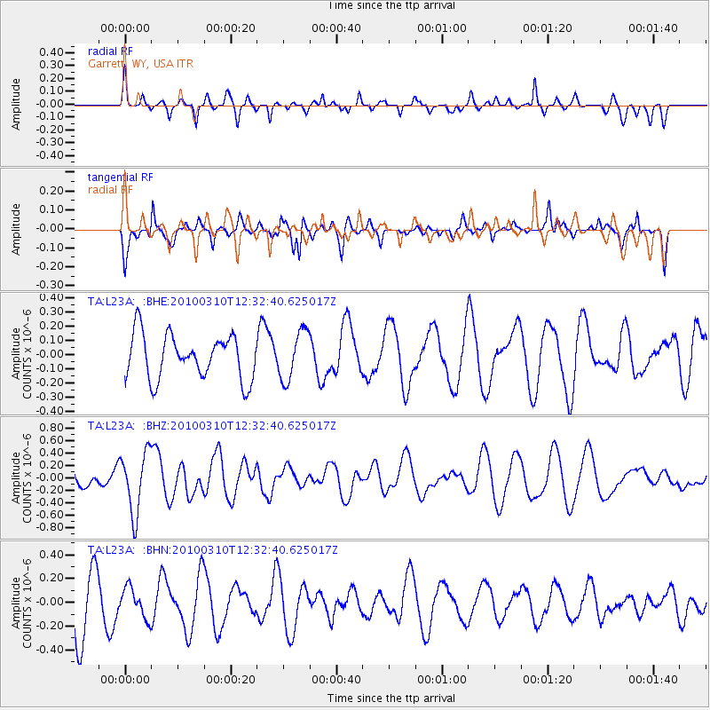
L23A Garrett, WY, USA - Earthquake Result Viewer
*The percent match for this event was below the threshold and hence no stack was calculated.
| Earthquake location: |
Off Coast Of Central Chile |
| Earthquake latitude/longitude: |
-33.6/-72.3 |
| Earthquake time(UTC): |
2010/03/10 (069) 12:20:58 GMT |
| Earthquake Depth: |
35 km |
| Earthquake Magnitude: |
5.5 MB, 5.5 MS |
| Earthquake Catalog/Contributor: |
WHDF/NEIC |
|
| Network: |
TA USArray Transportable Network (new EarthScope stations) |
| Station: |
L23A Garrett, WY, USA |
| Lat/Lon: |
42.11 N/105.70 W |
| Elevation: |
2153 m |
|
| Distance: |
81.3 deg |
| Az: |
335.52 deg |
| Baz: |
152.289 deg |
| Ray Param: |
$rayparam |
*The percent match for this event was below the threshold and hence was not used in the summary stack. |
|
| Radial Match: |
40.863014 % |
| Radial Bump: |
308 |
| Transverse Match: |
59.711304 % |
| Transverse Bump: |
357 |
| SOD ConfigId: |
299721 |
| Insert Time: |
2010-04-26 21:21:22.103 +0000 |
| GWidth: |
2.5 |
| Max Bumps: |
400 |
| Tol: |
0.001 |
|
Signal To Noise
| Channel | StoN | STA | LTA |
| TA:L23A: :BHZ:20100310T12:32:40.625017Z | 2.182634 | 4.917289E-7 | 2.252915E-7 |
| TA:L23A: :BHN:20100310T12:32:40.625017Z | 0.5887853 | 1.2626057E-7 | 2.1444245E-7 |
| TA:L23A: :BHE:20100310T12:32:40.625017Z | 1.1229261 | 1.7511478E-7 | 1.5594507E-7 |
| Arrivals |
| Ps | |
| PpPs | |
| PsPs/PpSs | |


