You are here: Home > Network List > CB - China National Seismic Network Stations List
> Station HHC Huhehaote,Neimeng Province > Earthquake Result Viewer
HHC Huhehaote,Neimeng Province - Earthquake Result Viewer
| Earthquake location: |
New Guinea, Papua New Guinea |
| Earthquake latitude/longitude: |
-6.5/143.3 |
| Earthquake time(UTC): |
2018/02/26 (057) 15:17:57 GMT |
| Earthquake Depth: |
5.2 km |
| Earthquake Magnitude: |
6.3 Mww |
| Earthquake Catalog/Contributor: |
NEIC PDE/us |
|
| Network: |
CB China National Seismic Network |
| Station: |
HHC Huhehaote,Neimeng Province |
| Lat/Lon: |
40.85 N/111.56 E |
| Elevation: |
1169 m |
|
| Distance: |
55.4 deg |
| Az: |
331.032 deg |
| Baz: |
140.625 deg |
| Ray Param: |
0.06483859 |
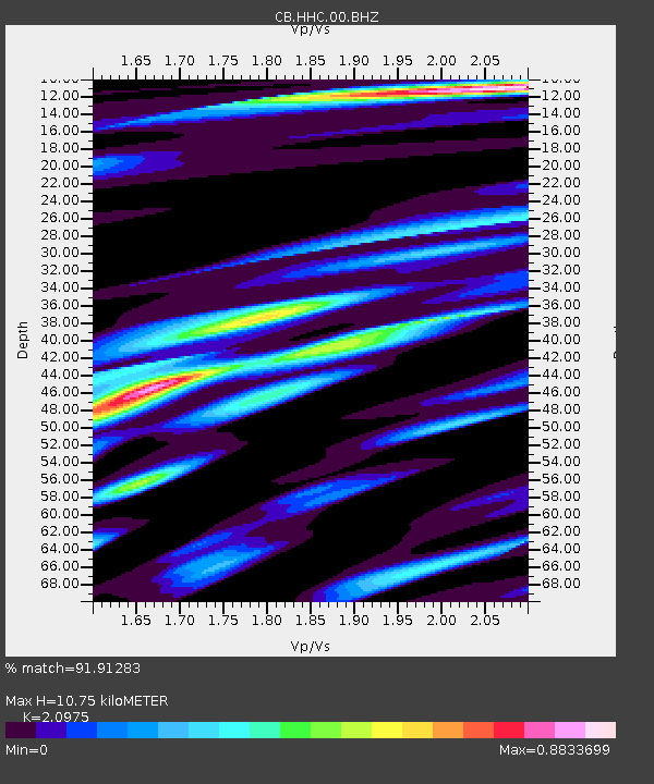
| Estimated Moho Depth: |
10.75 km |
| Estimated Crust Vp/Vs: |
2.10 |
| Assumed Crust Vp: |
6.384 km/s |
| Estimated Crust Vs: |
3.044 km/s |
| Estimated Crust Poisson's Ratio: |
0.35 |
|
| Radial Match: |
91.91283 % |
| Radial Bump: |
400 |
| Transverse Match: |
82.01077 % |
| Transverse Bump: |
400 |
| SOD ConfigId: |
2973751 |
| Insert Time: |
2018-10-09 08:44:02.460 +0000 |
| GWidth: |
2.5 |
| Max Bumps: |
400 |
| Tol: |
0.001 |
|

Signal To Noise
| Channel | StoN | STA | LTA |
| CB:HHC:00:BHZ:20180226T15:27:02.089993Z | 2.4094443 | 3.7614222E-7 | 1.561116E-7 |
| CB:HHC:00:BHN:20180226T15:27:02.089993Z | 1.786986 | 2.2616332E-7 | 1.2656133E-7 |
| CB:HHC:00:BHE:20180226T15:27:02.089993Z | 1.2075734 | 2.1246528E-7 | 1.75944E-7 |
| Arrivals |
| Ps | 1.9 SECOND |
| PpPs | 5.0 SECOND |
| PsPs/PpSs | 6.9 SECOND |


