You are here: Home > Network List > XA95 - Missouri to Massachusetts Transect Stations List
> Station MM18 Tyson, Missiouri > Earthquake Result Viewer
MM18 Tyson, Missiouri - Earthquake Result Viewer
| Earthquake location: |
Kuril Islands |
| Earthquake latitude/longitude: |
44.6/149.4 |
| Earthquake time(UTC): |
1995/12/03 (337) 18:01:08 GMT |
| Earthquake Depth: |
33 km |
| Earthquake Magnitude: |
6.6 MB, 8.0 MS |
| Earthquake Catalog/Contributor: |
WHDF/NEIC |
|
| Network: |
XA Missouri to Massachusetts Transect |
| Station: |
MM18 Tyson, Missiouri |
| Lat/Lon: |
38.53 N/90.57 W |
| Elevation: |
186 m |
|
| Distance: |
81.2 deg |
| Az: |
43.39 deg |
| Baz: |
321.242 deg |
| Ray Param: |
0.04771149 |
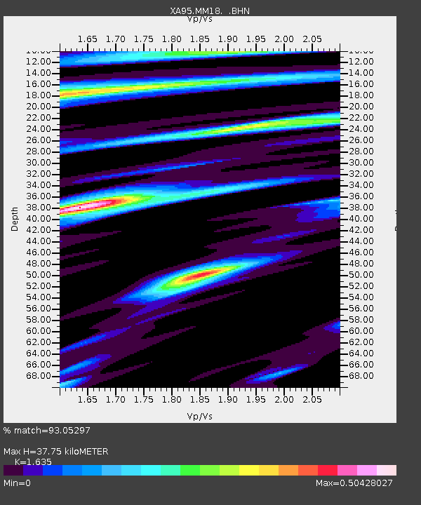
| Estimated Moho Depth: |
37.75 km |
| Estimated Crust Vp/Vs: |
1.63 |
| Assumed Crust Vp: |
6.498 km/s |
| Estimated Crust Vs: |
3.974 km/s |
| Estimated Crust Poisson's Ratio: |
0.20 |
|
| Radial Match: |
93.05297 % |
| Radial Bump: |
400 |
| Transverse Match: |
79.29797 % |
| Transverse Bump: |
400 |
| SOD ConfigId: |
6273 |
| Insert Time: |
2010-02-26 17:57:00.221 +0000 |
| GWidth: |
2.5 |
| Max Bumps: |
400 |
| Tol: |
0.001 |
|
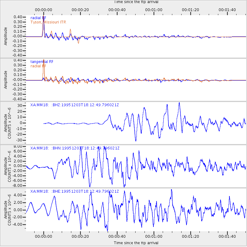
Signal To Noise
| Channel | StoN | STA | LTA |
| XA:MM18: :BHN:19951203T18:12:49.796021Z | 0.68945646 | 5.1901674E-7 | 7.527912E-7 |
| XA:MM18: :BHE:19951203T18:12:49.796021Z | 1.2826633 | 1.3488865E-6 | 1.0516294E-6 |
| XA:MM18: :BHZ:19951203T18:12:49.796021Z | 4.3955708 | 2.8544207E-6 | 6.493857E-7 |
| Arrivals |
| Ps | 3.8 SECOND |
| PpPs | 15 SECOND |
| PsPs/PpSs | 19 SECOND |


