MM18 Tyson, Missiouri - Earthquake Result Viewer
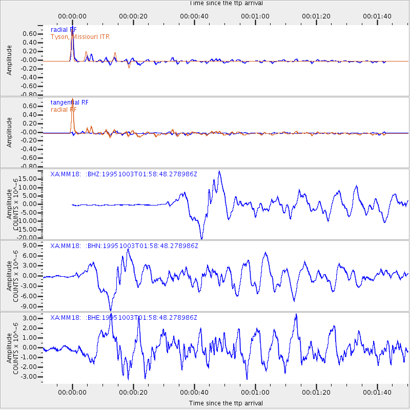
Earthquake location: Peru-Ecuador Border Region
Earthquake latitude/longitude: -2.8/-77.9
Earthquake time(UTC): 1995/10/03 (276) 01:51:24 GMT
Earthquake Depth: 27 km
Earthquake Magnitude: 6.5 MB, 7.0 MS, 6.9 UNKNOWN, 7.0 MW
Earthquake Catalog/Contributor: WHDF/NEIC
Network: XA Missouri to Massachusetts Transect
Station: MM18 Tyson, Missiouri
Lat/Lon: 38.53 N/90.57 W
Elevation: 186 m
Distance: 42.7 deg
Az: 345.298 deg
Baz: 161.144 deg
Ray Param: 0.072949536
Estimated Moho Depth: 32.5 km
Estimated Crust Vp/Vs: 1.92
Assumed Crust Vp: 6.498 km/s
Estimated Crust Vs: 3.38 km/s
Estimated Crust Poisson's Ratio: 0.31
Radial Match: 97.70783 %
Radial Bump: 329
Transverse Match: 83.07857 %
Transverse Bump: 400
SOD ConfigId: 6273
Insert Time: 2010-02-26 17:57:02.714 +0000
GWidth: 2.5
Max Bumps: 400
Tol: 0.001

Signal To Noise

ChannelStoNSTALTA
XA:MM18: :BHN:19951003T01:58:48.278986Z5.6842489.374643E-71.649232E-7
XA:MM18: :BHE:19951003T01:58:48.278986Z2.40994523.6278533E-71.5053675E-7
XA:MM18: :BHZ:19951003T01:58:48.278986Z9.0049991.5942354E-61.7703893E-7
Arrivals
Ps4.9 SECOND
PpPs14 SECOND
PsPs/PpSs19 SECOND