You are here: Home > Network List > TA - USArray Transportable Network (new EarthScope stations) Stations List
> Station 130A Snyder, TX, USA > Earthquake Result Viewer
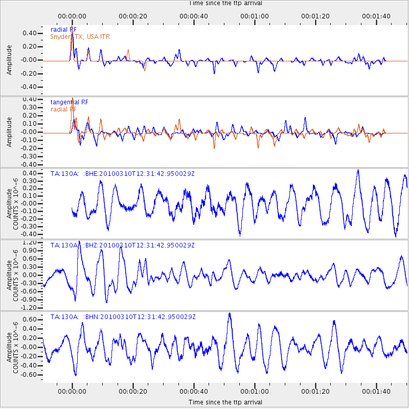
130A Snyder, TX, USA - Earthquake Result Viewer
*The percent match for this event was below the threshold and hence no stack was calculated.
| Earthquake location: |
Off Coast Of Central Chile |
| Earthquake latitude/longitude: |
-33.6/-72.3 |
| Earthquake time(UTC): |
2010/03/10 (069) 12:20:58 GMT |
| Earthquake Depth: |
35 km |
| Earthquake Magnitude: |
5.5 MB, 5.5 MS |
| Earthquake Catalog/Contributor: |
WHDF/NEIC |
|
| Network: |
TA USArray Transportable Network (new EarthScope stations) |
| Station: |
130A Snyder, TX, USA |
| Lat/Lon: |
32.60 N/100.97 W |
| Elevation: |
676 m |
|
| Distance: |
71.1 deg |
| Az: |
334.663 deg |
| Baz: |
154.956 deg |
| Ray Param: |
$rayparam |
*The percent match for this event was below the threshold and hence was not used in the summary stack. |
|
| Radial Match: |
66.33984 % |
| Radial Bump: |
318 |
| Transverse Match: |
71.65808 % |
| Transverse Bump: |
374 |
| SOD ConfigId: |
299721 |
| Insert Time: |
2010-04-26 21:28:23.170 +0000 |
| GWidth: |
2.5 |
| Max Bumps: |
400 |
| Tol: |
0.001 |
|
Signal To Noise
| Channel | StoN | STA | LTA |
| TA:130A: :BHZ:20100310T12:31:42.950029Z | 3.433661 | 6.389415E-7 | 1.860817E-7 |
| TA:130A: :BHN:20100310T12:31:42.950029Z | 1.847616 | 3.26372E-7 | 1.7664493E-7 |
| TA:130A: :BHE:20100310T12:31:42.950029Z | 0.7749294 | 1.11084624E-7 | 1.4334805E-7 |
| Arrivals |
| Ps | |
| PpPs | |
| PsPs/PpSs | |


