You are here: Home > Network List > TA - USArray Transportable Network (new EarthScope stations) Stations List
> Station S29A Ulysses, KS, USA > Earthquake Result Viewer
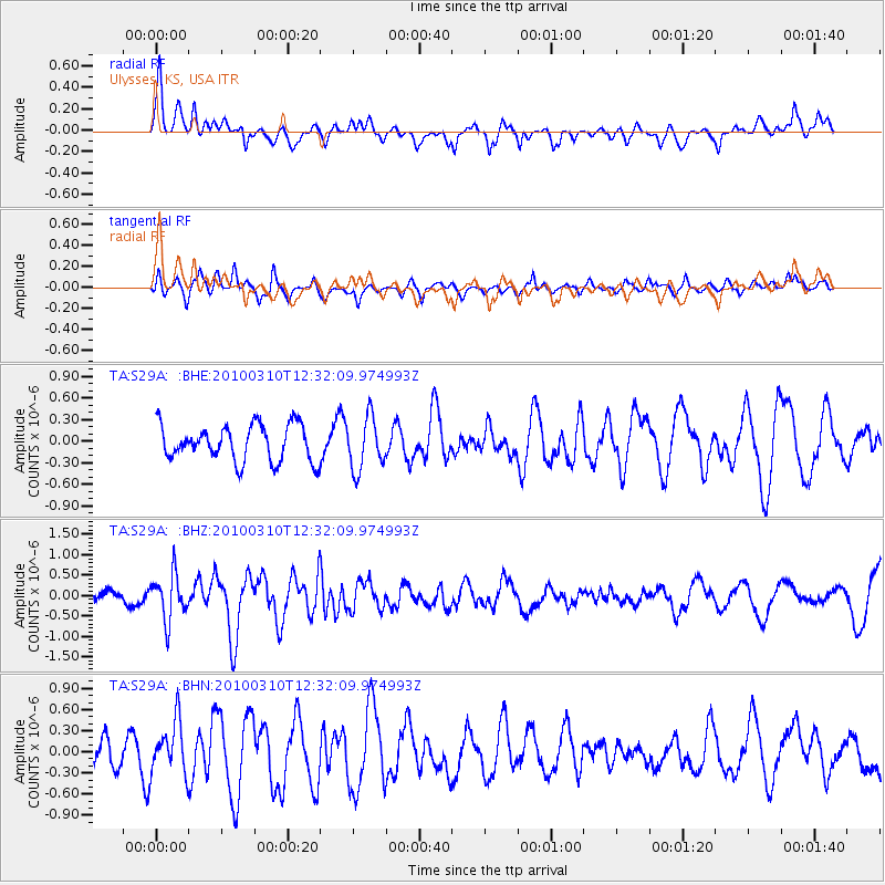
S29A Ulysses, KS, USA - Earthquake Result Viewer
*The percent match for this event was below the threshold and hence no stack was calculated.
| Earthquake location: |
Off Coast Of Central Chile |
| Earthquake latitude/longitude: |
-33.6/-72.3 |
| Earthquake time(UTC): |
2010/03/10 (069) 12:20:58 GMT |
| Earthquake Depth: |
35 km |
| Earthquake Magnitude: |
5.5 MB, 5.5 MS |
| Earthquake Catalog/Contributor: |
WHDF/NEIC |
|
| Network: |
TA USArray Transportable Network (new EarthScope stations) |
| Station: |
S29A Ulysses, KS, USA |
| Lat/Lon: |
37.62 N/101.12 W |
| Elevation: |
931 m |
|
| Distance: |
75.7 deg |
| Az: |
336.736 deg |
| Baz: |
155.46 deg |
| Ray Param: |
$rayparam |
*The percent match for this event was below the threshold and hence was not used in the summary stack. |
|
| Radial Match: |
59.365765 % |
| Radial Bump: |
400 |
| Transverse Match: |
43.23901 % |
| Transverse Bump: |
373 |
| SOD ConfigId: |
299721 |
| Insert Time: |
2010-04-26 21:29:50.286 +0000 |
| GWidth: |
2.5 |
| Max Bumps: |
400 |
| Tol: |
0.001 |
|
Signal To Noise
| Channel | StoN | STA | LTA |
| TA:S29A: :BHZ:20100310T12:32:09.974993Z | 4.926989 | 5.540574E-7 | 1.1245355E-7 |
| TA:S29A: :BHN:20100310T12:32:09.974993Z | 1.2297653 | 3.654136E-7 | 2.9714093E-7 |
| TA:S29A: :BHE:20100310T12:32:09.974993Z | 1.4688696 | 3.636881E-7 | 2.4759728E-7 |
| Arrivals |
| Ps | |
| PpPs | |
| PsPs/PpSs | |


