You are here: Home > Network List > CI - Caltech Regional Seismic Network Stations List
> Station TIN Tinemaha, Big Pine, CA, USA > Earthquake Result Viewer
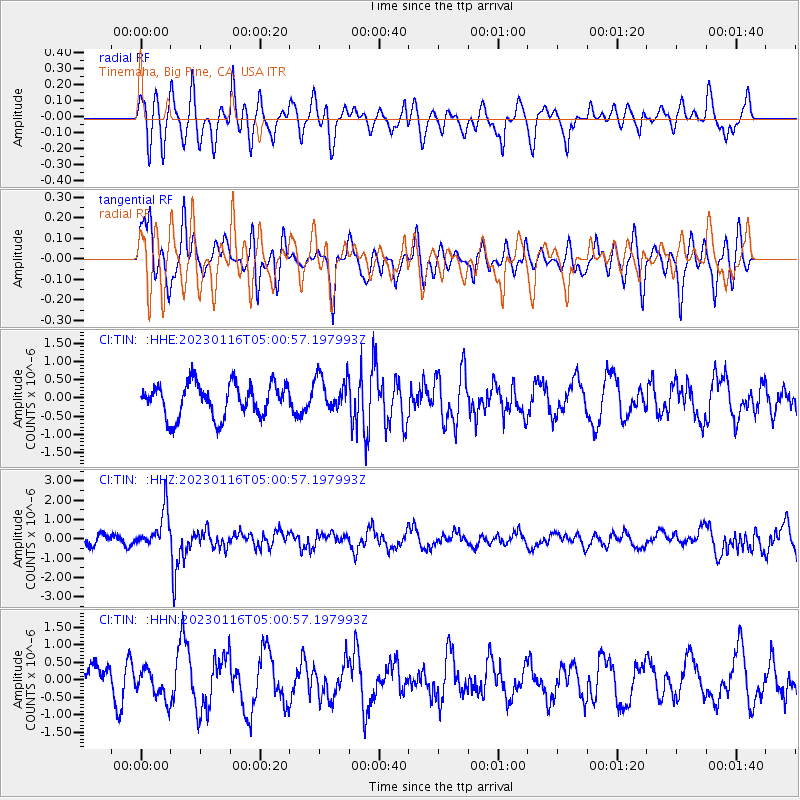
TIN Tinemaha, Big Pine, CA, USA - Earthquake Result Viewer
*The percent match for this event was below the threshold and hence no stack was calculated.
| Earthquake location: |
Bonin Islands, Japan Region |
| Earthquake latitude/longitude: |
29.0/139.4 |
| Earthquake time(UTC): |
2023/01/16 (016) 04:49:52 GMT |
| Earthquake Depth: |
405 km |
| Earthquake Magnitude: |
6.3 mww |
| Earthquake Catalog/Contributor: |
NEIC PDE/us |
|
| Network: |
CI Caltech Regional Seismic Network |
| Station: |
TIN Tinemaha, Big Pine, CA, USA |
| Lat/Lon: |
37.05 N/118.23 W |
| Elevation: |
1197 m |
|
| Distance: |
82.0 deg |
| Az: |
52.086 deg |
| Baz: |
300.233 deg |
| Ray Param: |
$rayparam |
*The percent match for this event was below the threshold and hence was not used in the summary stack. |
|
| Radial Match: |
52.67613 % |
| Radial Bump: |
400 |
| Transverse Match: |
63.0657 % |
| Transverse Bump: |
400 |
| SOD ConfigId: |
29823551 |
| Insert Time: |
2023-01-30 05:04:02.914 +0000 |
| GWidth: |
2.5 |
| Max Bumps: |
400 |
| Tol: |
0.001 |
|
Signal To Noise
| Channel | StoN | STA | LTA |
| CI:TIN: :HHZ:20230116T05:00:57.197993Z | 2.7544792 | 9.863293E-7 | 3.5808196E-7 |
| CI:TIN: :HHN:20230116T05:00:57.197993Z | 1.009885 | 4.4027877E-7 | 4.3596924E-7 |
| CI:TIN: :HHE:20230116T05:00:57.197993Z | 1.0449159 | 4.778378E-7 | 4.5729783E-7 |
| Arrivals |
| Ps | |
| PpPs | |
| PsPs/PpSs | |


