You are here: Home > Network List > TA - USArray Transportable Network (new EarthScope stations) Stations List
> Station S31A Mullinville, KS, USA > Earthquake Result Viewer
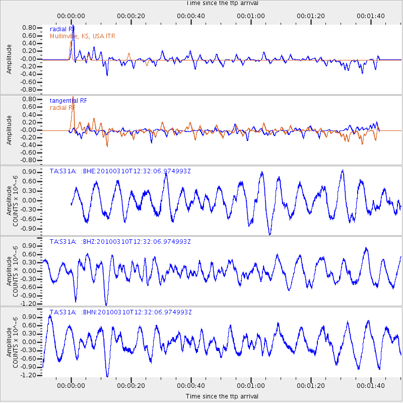
S31A Mullinville, KS, USA - Earthquake Result Viewer
*The percent match for this event was below the threshold and hence no stack was calculated.
| Earthquake location: |
Off Coast Of Central Chile |
| Earthquake latitude/longitude: |
-33.6/-72.3 |
| Earthquake time(UTC): |
2010/03/10 (069) 12:20:58 GMT |
| Earthquake Depth: |
35 km |
| Earthquake Magnitude: |
5.5 MB, 5.5 MS |
| Earthquake Catalog/Contributor: |
WHDF/NEIC |
|
| Network: |
TA USArray Transportable Network (new EarthScope stations) |
| Station: |
S31A Mullinville, KS, USA |
| Lat/Lon: |
37.62 N/99.48 W |
| Elevation: |
700 m |
|
| Distance: |
75.2 deg |
| Az: |
337.961 deg |
| Baz: |
156.761 deg |
| Ray Param: |
$rayparam |
*The percent match for this event was below the threshold and hence was not used in the summary stack. |
|
| Radial Match: |
64.348885 % |
| Radial Bump: |
400 |
| Transverse Match: |
36.78777 % |
| Transverse Bump: |
345 |
| SOD ConfigId: |
299721 |
| Insert Time: |
2010-04-26 21:30:03.453 +0000 |
| GWidth: |
2.5 |
| Max Bumps: |
400 |
| Tol: |
0.001 |
|
Signal To Noise
| Channel | StoN | STA | LTA |
| TA:S31A: :BHZ:20100310T12:32:06.974993Z | 1.6653067 | 4.176695E-7 | 2.5080635E-7 |
| TA:S31A: :BHN:20100310T12:32:06.974993Z | 0.77853584 | 3.6136774E-7 | 4.6416326E-7 |
| TA:S31A: :BHE:20100310T12:32:06.974993Z | 1.406539 | 4.987176E-7 | 3.5457077E-7 |
| Arrivals |
| Ps | |
| PpPs | |
| PsPs/PpSs | |


